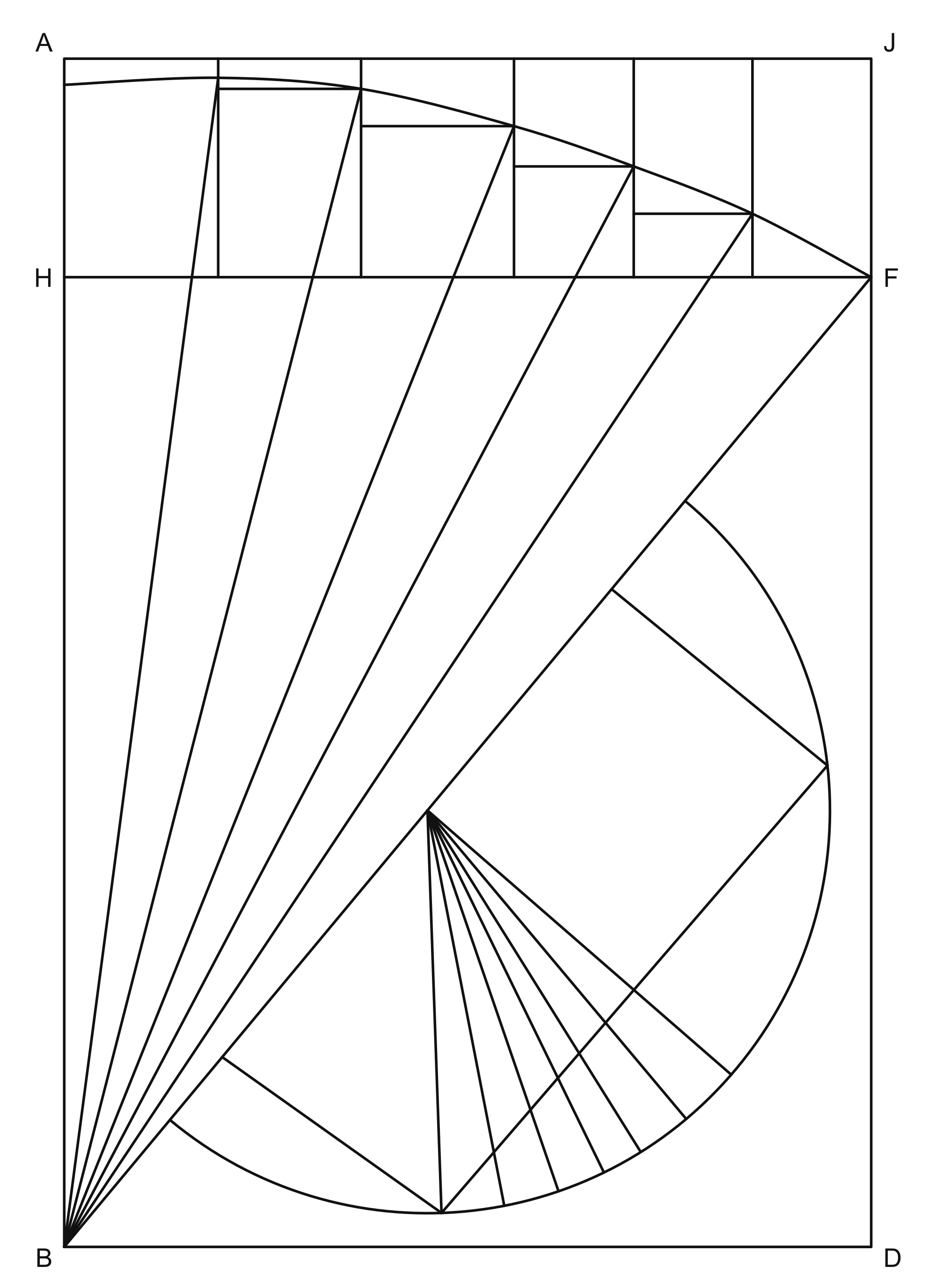
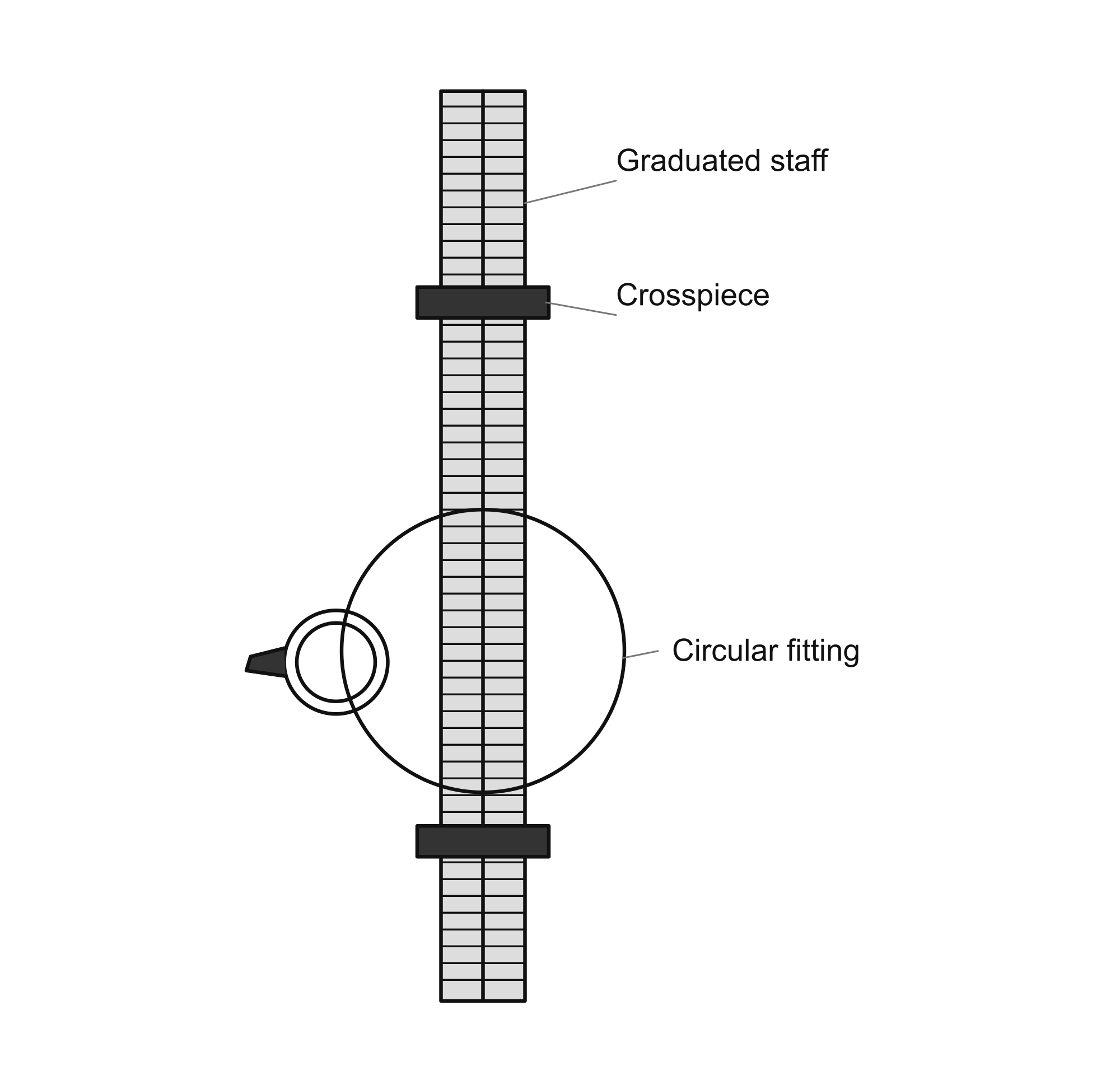
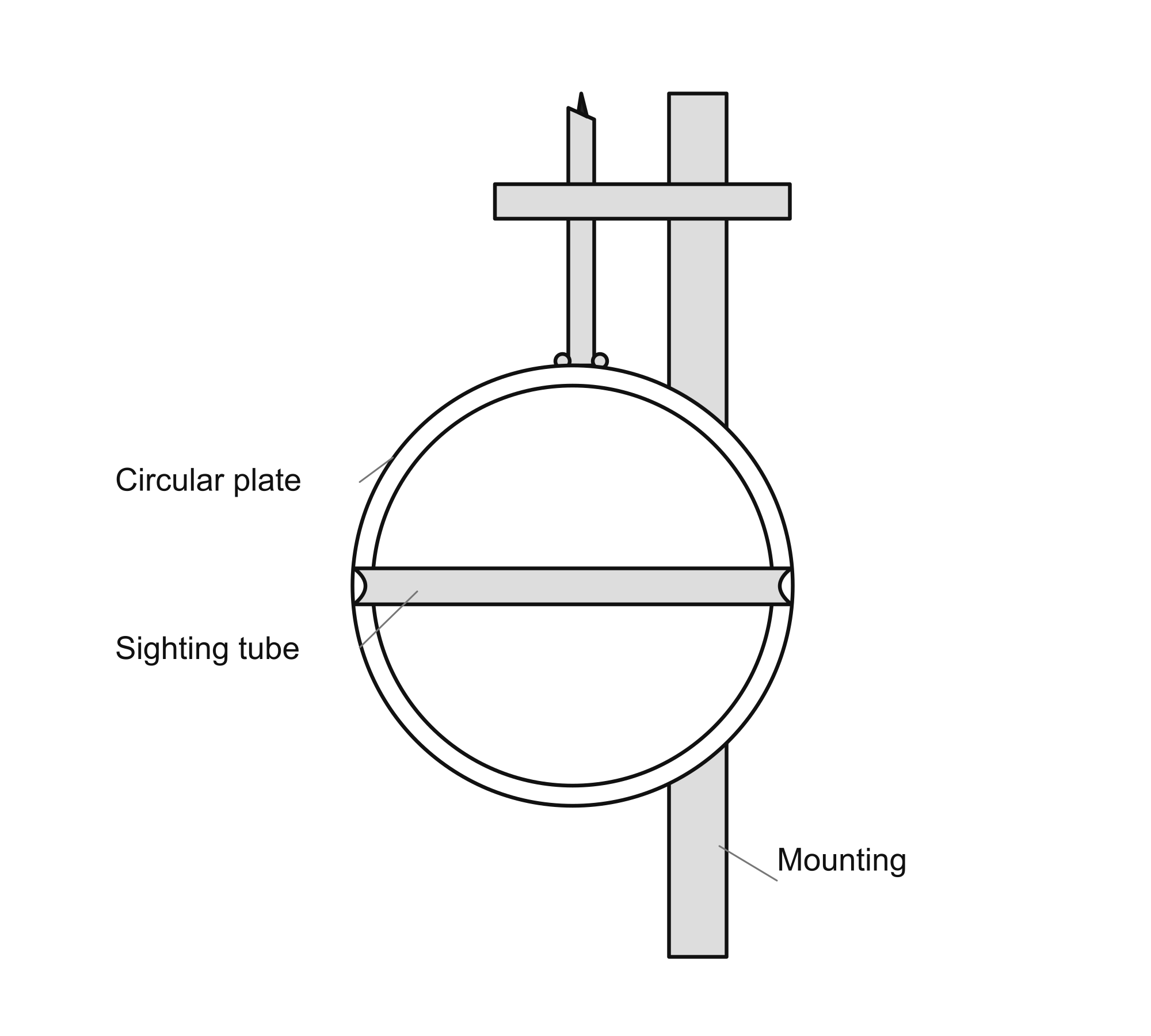
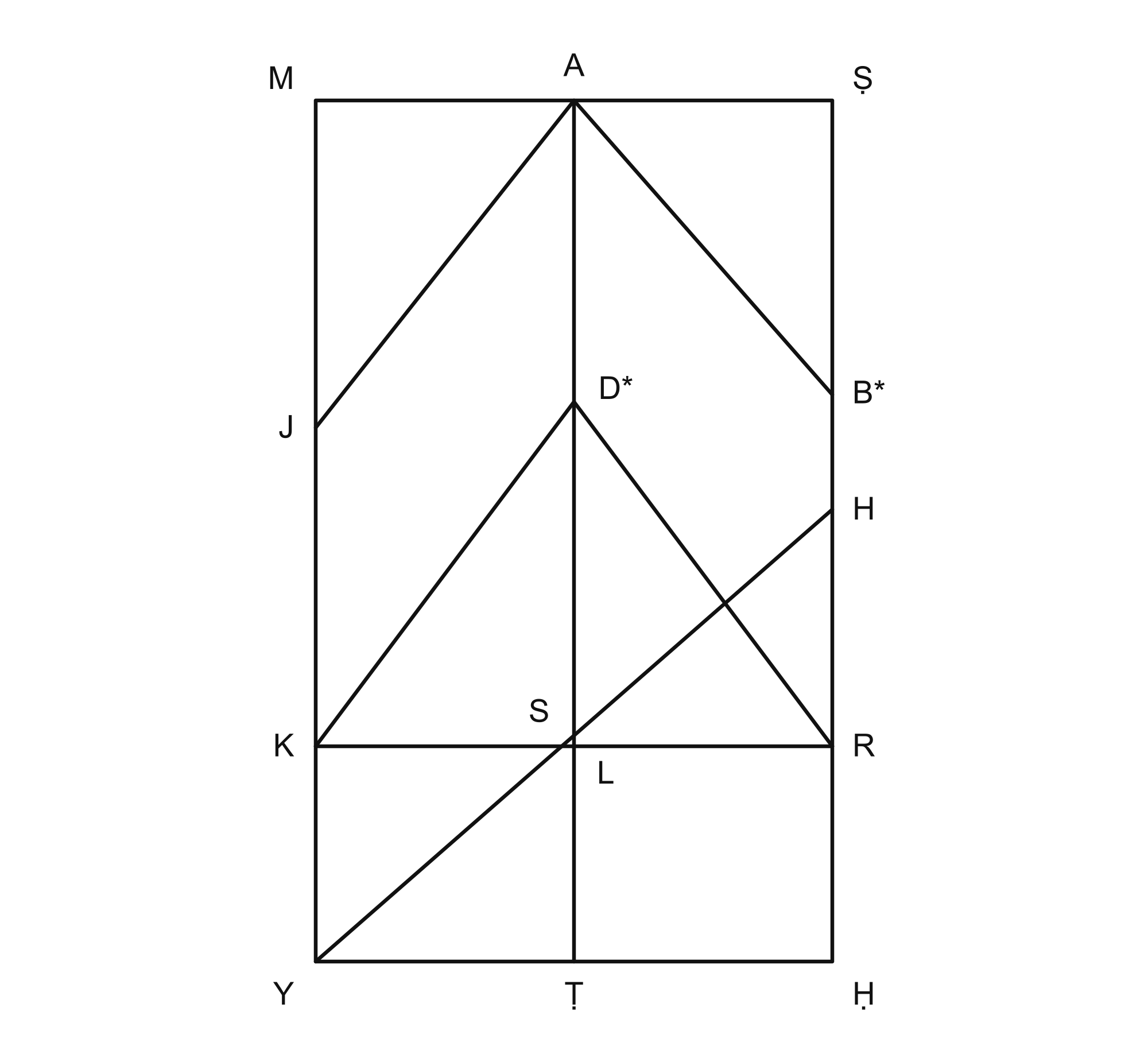
An English Reader’s Edition from Manuscript LJS 399
English edition prepared by Hidden Waters project
Source: University of Pennsylvania Libraries, Kislak Center for Special Collections, Rare Books and Manuscripts, Lawrence J. Schoenberg Collection, LJS 399, Inbat al-miyah al-khafiyah. The manuscript text occupies folios 1v–48r. The 1674 copying date follows Penn’s catalog. Penn marks the manuscript images and contents as public domain, and the item’s metadata as CC0. This edition contains newly typeset English and redrawn figures; no manuscript scans are included. The separate supplement derives from the Hyderabad Arabic edition, printed pp. 11–13. No images of that edition are reproduced.
Introduction
This book concerns the search for water beneath the earth and the work required to bring it to the surface. Its author, Muhammad ibn al-Husayn al-Karaji, moves between natural philosophy, observation, surveying, construction and the rights of neighboring water users. A qanat is the central practical setting: an underground gallery that collects water and carries it toward an outlet, usually with a sequence of shafts connecting the work to the surface.
The Arabic work belongs to the eleventh century. The manuscript used for this edition, University of Pennsylvania Libraries LJS 399, was copied in 1674. The date in its closing note belongs to that copy, not to the original composition. The surviving copy contains both prose and geometrical drawings, including levels, sighting instruments and methods of measuring an underground route and locating it at the surface.
Read as a whole, the treatise joins several kinds of knowledge. Observations about soils, vegetation and seasonal supply lead into questions about interference between wells. Discussions of excavation and lining lead into the measurement of slopes. The later chapters return to the practical tasks of alignment, maintenance and receiving a contractor’s completed work. The diagrams belong to these arguments; they are technical evidence rather than ornament.
This reader’s edition is being prepared from LJS 399. It preserves the author’s historical explanations and units of measure. It does not silently replace his natural philosophy with modern hydrology, or replace a difficult mathematical proof with a modern derivation. Newly drawn figures follow the manuscript’s visible structure. Where the labels or reasoning are unresolved, the limits of the reconstruction are stated. A separately labelled supplement translates material from the Hyderabad Arabic edition corresponding to the break between folios 7v and 8r; it is kept outside the manuscript sequence.
Reading the edition
Folio references identify manuscript leaves: r means recto (front), and v verso (back). They allow comparison with LJS 399 without reproducing its scans.
Part titles, paragraphs and punctuation are editorial. Headings within the translation follow the manuscript’s rubrics where recovered.
Square brackets mark gaps, qualified restorations, uncertain readings or editorial explanations. The restorations at 5v–6r and 48r are identified in the notes. Two defective arithmetic instructions on 38v are restored from the proof on 40r; the divisor correction there is also declared. Continuation ellipses alone do not indicate missing text.
Cubit, span, finger and dirham remain historical units, without fixed modern conversions. Construction methods, medical judgments and legal opinions are presented as historical material.
Captions distinguish visible features from interpretation. J represents jim; H/Ḥ and S/Ṣ distinguish different Arabic letters. An asterisk marks a point restored from prose or provisionally normalized, as explained in the caption. Unverified letters are omitted. A faithful redraw can preserve an error in the manuscript’s geometry.
The calibration proof on 27v–28v uses geometrical positions where intermediate point letters remain insecure. This is not a letter-for-letter transcription. The angle and proportion arguments are retained, and the inconsistent small diagram is identified.
The opening names Muhammad ibn al-Hasan al-hasib. Penn’s catalog and this edition’s bibliographic heading use Muhammad ibn al-Husayn al-Karaji. Both readings are recorded.
A textual break occurs between 7v and 8r despite the complete, consecutive digital sequence. A separate supplement translates corresponding material directly from the Hyderabad Arabic edition, printed pp. 11–13. Its source and boundary overlaps are stated; it is not inserted as a Penn manuscript leaf.
In the name of God, the Merciful, the Compassionate; in Him we seek help.
[Praise be to God …] and His blessings upon Muhammad, the seal of His prophets, the bearer of His message and the deliverer of His promise and warning, and upon his chosen family.
Muhammad ibn al-Hasan, the calculator, says: When I entered Iraq, I saw that its people, young and old, loved learning and esteemed its worth. From time to time I therefore composed a work on calculation or geometry. When I returned to the land of the mountains, I did not find there the conditions I have described in Iraq. My impulse to compose grew dull and my inclination to write grew cold, until God came to the aid of its lands and people through the excellence of our master, the chief vizier, the most exalted lord, favored and beneficent, Abu Ghanim Ma'ruf ibn Muhammad—may God prolong his life in honor and enduring prosperity, advance him to the highest ranks, and make his banners and supporters flourish wherever he stands. [A short wish concerning his enemies remains uncertain.]
Through the blessing of his government, his good administration, his fortunate care for people's affairs, the attention he gives them in every respect, his comprehensive justice and encompassing protection, they came to enjoy the flourishing days of his rule, sheltered by his favor. Some praised his excellence; others commended his administration. I then resumed my former practice and began to compose this book, entitled The Extraction of Hidden Waters, seeking his favor, after examining something of …
… the books of earlier writers, and found them inadequate to the need and short of the intended goal. I pray to God, mighty and exalted, that He may raise him to ever higher rank, spread his achievement through east and west, and extend his excellence and justice to all the people of the earth; that time may return clothed in its finest garments, freed from troublesome blemishes, with its virtues restored; that the effaced signs of learning may be renewed and the fear of oppression removed by the coming of justice, through His power and success.
I know of no craft of greater benefit or more abundant usefulness than the extraction of hidden waters, through which the earth is cultivated and its people live. Since its benefit is so great, I begin with a description of the earth, its disposition, and its place in the world.
The earth and hidden water
After what I have mentioned, I say that the earth is spherical, together with all the mountains, hollows, descents, and ascents upon it. Its place, which God created for it, is the center of the world. It always seeks that place by the motion created in it. Its size in relation to the world is exceedingly small.
God—blessed and exalted—created the world as a solid whole with no void in it. He assigned a particular place to each of the celestial spheres, stars, fire, air, water, and earth. When a thing is separated from its place, it seeks it by its motion. Dense bodies, such as earth and water, seek the center just mentioned; the denser precedes the other toward it. For our purpose we need not discuss what lies beyond water.
It follows that the earth is at the center and water surrounds it. If the earth were a perfect sphere, solid and admitting no water, and all the lines from its center to its surface were equal, the water would surround all of it as the white of an egg surrounds its yolk, whether …
… the water were little or much. The surface of the sphere of water would be parallel to the surface of the sphere of earth. Water would have no flow, and the earth would form one sea.
If the earth were as we have described—perfectly spherical, with equal lines from the center to its surface—but contained pores of a uniform kind, water could be in only one of three conditions. It might cover the earth, making it one sea; it might lie flush with its surface, leaving its face one expanse of land; or it might lie below the surface, collected in its interior. The surface of the earth would be parallel to that of the water. In none of these three conditions would water flow. If the water lay below the surface, it would be reached at one uniform depth and could be raised only by water wheels and lifting devices.
I have mentioned this so that water's nature may be understood: in flowing, it seeks the spherical form, and when it reaches that form, it ceases to flow. The elevations and mounds rising above the earth's surface and the slopes descending toward the center must therefore be considered together with the spherical earth and what follows from it.
Since God—exalted be His remembrance—willed that water should flow and move from place to place, that the earth should have land and sea, and that there should be land and aquatic animals, crops, fruits, varieties of plants, minerals, and everything needed for their cultivation and life—things to eat and drink and wear, precious substances, and medicines—He made mountains and plains, heights and descents, summits and depths, of many kinds of stone and differing clays. Thus the lines extending …
… from the center of the world to the earth's surface are unequal. Water flowed from places farther from the center toward places nearer it, uncovering the more distant places and making them a home for land animals. Water continued to flow from them toward the nearer places. Air changes into water in cold seasons and cold places when it becomes dense; water changes into air in hot seasons and hot places when it becomes rarefied. These transformations have great benefits for the cultivation of the earth.
Among the manifestations of God's great wisdom is that He made the sun travel in its sphere along a circle that crosses the circle about whose poles the first motion takes place—the motion that produces night and day, namely the equinoctial circle. Half of the sun's circle lies to its north and half to its south. This brings about the changing times and their division into spring, summer, autumn, and winter. The differences between these seasons sustain the earth's cultivation and the animals upon it.
By His wisdom, God created many regions of the earth with mountains connected to one another for many parasangs in length and breadth. Between them are ravines, low grounds, and interconnected passages. In winter, when the air grows dense and the cold intense, the air changes powerfully into water, and great snows fall upon these mountains …
… which do not disappear in winter or summer. When the sun's heat grows strong there, some of the snow melts. It supplies the springs, rivers, qanats, and wells. Some of its water runs through the earth's veins and the grooves within it, supplying springs in distant places.
God has made narrow and wide passages for water inside the earth, with barriers of stone, kadhdhan stone, and hard clay. Some barriers stand upright; others lie spread across the earth's surface or within it; others turn in different directions between its interior and exterior. They resemble the nerves and arteries in an animal's body. He made the soils differ greatly in all these respects so that water would not pervade the earth, take a spherical form, gather, and cease to flow. Instead it occupies one place rather than another, rises in one place and runs in another, and rests at a depth far from the surface or close to it. In some places its supply never ceases.
There is no standing or flowing water on the earth's surface or within it whose supply does not come from a place farther from the center than the place where it appears and flows. Because it is by nature spherical, it cannot do otherwise. Great rivers and powerful waters are supplied by the snow accumulated in the mountains already described—snow that never disappears. This occurs in regions of high latitude where few animals live.
God created earth and water and assigned a supply to each. As for water resting within the earth, and springs, valleys, rivers, and fountains, their supplies are the rains …
… and snow. If they cease, the waters diminish and the land falls into ruin.
I have heard of islands with strong springs of fresh water. Their supply does not come from the sea surrounding them: the sea's surface is below the surface of their land, and its water is salty whereas theirs is fresh. Their supply comes instead from distant places higher than themselves. The snow mentioned earlier is melted by the sun, and its water runs beneath the ground in winter and summer. The great rivers are supplied from such places.
This is shown by their increase in spring, when the sun passes over the place of their supply and melts the snow there. This applies when their source lies to the north. When it lies to the south, their increase occurs when the sun enters Libra and Scorpio, because it then approaches the direction of the snow. This is the case with the Nile: its source lies to the south, so its increase appears in Egypt, to the north, in autumn.
Most supplies of water in the inhabited region come from places of high latitude, nearer the northern pole, where moisture is abundant. Dense air there undergoes continual change into water, feeding rivers, springs, and the earth's veins and openings. In the inhabited part of the earth there are mountains of the kind already described; the melting of their snow, and the springs and lakes in their interiors and ravines, collect into …
… medium-sized rivers whose beginnings and ends are known. Springs also gather into streams and smaller rivers. In many places I have seen water issue from a rocky mountain foot in great quantity. Many great rivers originate close to a strong source of supply.
Some philosophers have said that air changes into water in the earth's cold interior, and that this produces its water. The visible waters which never cease flowing are fed, as already mentioned, by springs and watercourses in the earth's interior. They emerge on its surface because their outlet is nearer the center than their place of supply. When water runs within hard earth and encounters a rock through which it finds an opening, it flows out to the surface of the mountain at whatever elevation that outlet occupies, provided it is nearer the center than the source of the water flowing through it.
The philosophers have said that a spring's supply may be above the mountain, arising from a cavity in its interior full of vapor. The vapor rises toward the summit and changes into water, which appears at its peak. Related to this is the following. Just as God has created the earth with springs flowing without excavation or human labor, so He has created places where water collects beneath the snow accumulated in mountain ravines, in loose clayey or sandy ground. Water sinks through these places and feeds the veins already mentioned, or …
… the water permanently resting inside the earth, and becomes its supply. Much water is retained underground until it reaches hard soil that prevents it from sinking farther. It stops there; if a channel is opened above that barrier, water runs through it according to its strength. Practitioners call this water ma’ al-tawwab. The places where water sinks into the earth are not themselves flowing springs; rather, they supply these underground veins.
Near a village called Kanda, in the district of Sawa, I saw a valley running between two mountains. Its water was fresh. In the middle of the water stood a rock with three holes, from which bitter water issued that purged anyone who drank it. There is no doubt that the water issuing from this rock was not supplied by the valley's water. It was other water whose character had changed because of the earth through which it passed.
Sailors report that in certain places on the seabed fresh water wells up. I consider this impossible: the sea's surface is nearer to the center than all the land surrounding it, and its bed is nearer to the center than its surface. Thus original water cannot rise there with the force with which water wells up from the earth's surface and veins.
Someone may object: You have supposed the earth to be spherical, although it bears great mountains, hollows, ascents, and descents. These prevent it from being perfectly round. Moreover, every part of it seeks the center and naturally seeks a spherical form. This would require …
“… that it should be continually moving and never at rest, like water, which seeks the spherical form; yet we find it as described, without movement.”
The answer is that the heights, descents, mountains, and valleys upon the earth's surface are negligible in comparison with the magnitude of the earth as a whole. Every weight is balanced by a corresponding weight in the opposite direction from the center of the world. Even if the earth were a cube of equal dimensions, or another body bounded by plane surfaces around which a sphere could be drawn, it would stand at the world's center. Whatever lay farther from the center in one direction would be balanced approximately by what lay opposite it in the other direction. The earth seeks the center by its own nature, without something pushing or pulling it.
Its solidity and the mountains upon it prevent its parts from leveling down until it becomes a perfectly rounded sphere. If the whole earth consisted of loose particles, its substance would be uniform but it would be unfit for cultivation. Water, if abundant enough, would cover it according to the same arrangement throughout its interior; if less abundant, it would lie hidden, with no outlet by which it could be extracted.
If the earth had a cubic form with unequal dimensions and stood at the center of the world, the parts surrounding the center would nevertheless have to balance. Their solidity and density would prevent them from being displaced. If they were entirely separate and unrestrained, the earth would take its spherical form. [Since the earth’s attaining its form, or water its form, would bring about the desolation of …]
[… the earth,] God created it with this wisdom, furnished with mountains, valleys, ascents, and descents. Some places upon it are farther from the center than others, while the surrounding weights remain approximately balanced about that center. The earth as a whole is therefore spherical. He created the water to fill its hollows and the veins within its interior; the excess flows into the seas. Accordingly, most water comes from snow and rain, while water changes into air and air into water. Places farther from the center are uncovered and become homes for land animals; those nearer the center are covered and inhabited by aquatic animals. If water were scarce upon the earth, its flow would cease or fall short, and cultivation would fail.
I also say that the earth has continual movements. Buildings tend to fall and collapse, inclining from their upright position. Mountains and their peaks likewise break down little by little and crumble in seeking the center. Loose ground is constantly in motion and seeks that its parts should press together and hold one another firm.
The greatest of these movements is the transfer of large bodies of water and the flow of rivers from one part of the earth to another over long periods. When their supplies gather in one place, their surface rises and moves farther from the center. The corresponding place on the opposite side no longer balances it, and the earth moves in pursuit …
… of the equilibrium just described. This changes the latitudes, rising points, and meridians of places. This causes the seas to shift, springs to appear, and springs to sink away. These changes do not occur all at once in a single year, but gradually, like the transfer of inhabited regions from one land to another.
According to those who attribute the desolation of the south to the sun’s perigee being aligned with it, habitation in the north must shift towards the south as the apogee moves into alignment with that region. This takes eighteen thousand years: the time in which the apogee moves to the place of the perigee according to Ptolemy, because its motion is one degree in every hundred years. God knows best concerning this. Whoever conceives what I have described and understands it has learned a large part of the craft of extracting water. Understanding the nature of the earth and its waters, their character and constitution, and the condition of water in its interior gives strong knowledge in this craft.
Discourse on hidden waters
After this account, we say that water has a source residing within the earth; it flows from the earth as blood flows from an animal’s body. It does not increase with increased rain or diminish when rainfall diminishes, as the ancients have said, because its supply comes from the transformation of air into water within the earth. This water extends through most of the interstices in the earth’s body, its parts connected with one another unless barriers and hard places prevent it. This water flows from …
… a place farther from the center to one nearer it, through the veins and pores of the earth. Just as water stands in one place upon the surface and flows in another, so it does beneath the ground. Most still water lies beneath flat deserts and broad plains, and is reached at a depth. It is supplied by water from snow lying lengthwise and across upon mountains: the ravines preserve the snow until the sun melts it. Water is stronger beneath such plains than elsewhere, because these mountains are reservoirs for the surrounding earth, unless the obstacles already mentioned prevent its passage.
The surfaces of these mountains which face the northern pole are moister than those facing east and west, and moister still than those facing south. The sun passes over the southern surfaces from the beginning of the day to its end, and removes the fresh, fine part of the water, changing it into air. For the same reason seawater becomes thick and not fresh: over long periods the sun removes its fresh and fine portion.
Evidence of this is that sailors obtain fresh water from the bottom of the sea and drink it. Their method is to make a vessel of lead with small holes in its base. It has a long tube made of thin, waxed leather, so that water cannot enter through its seams. A fitted ball closes its mouth, and a cord attached to the ball passes along the middle of the tube for its whole length. The vessel is lowered …
… to the bottom of the sea. When it reaches the bottom, pull the cord attached to the ball in the vessel's mouth, so that the air inside finds an outlet through the tube and [water] enters through the small holes. Then draw up the vessel by a cord attached to a handle fitted upon it. The water you find in it is fresh. Further evidence that the sun removes water's fresh, fine portion is that water standing in a pool, a well, or a spring with a weak supply does not remain fresh indefinitely.
Know that water cannot fill the whole earth, because its interior contains many barriers, some upright, some horizontal, and some inclined. Consequently, parts of the earth contain strong or weak springs, whether their flow ceases or continues, and other parts have wells with only deep water. Seas overflowing with water are not found on dry land except at the time of the Flood. Evidence of what we have said is the appearance of springs on the edge of a dry plain, while the water in its interior lies deep.
The differences in the earth's soil, and the presence of many barriers and obstacles within it, are shown by the existence of places whose soil is dry because it is dense. Other places, like the land of Iraq, contain water everywhere because their pores are interconnected, their substance is alike throughout, and barriers and obstacles are absent. In such ground the water in wells rises when the supply to the rivers increases and falls when it diminishes. The surface of the well water is level with that of the rivers. In one year the Tigris rose, and embankments were made against it to protect the land from the water, but …
[The next digitized page begins in a different passage. See the separately labelled Supplement to the textual break for material translated from the Hyderabad Arabic edition.]
… nearer the center, at a smaller depth than one reached in ground farther from the center. The water throughout has one supply.
Ground bearing abundant vegetation without sowing has water close beneath it, especially if the plants are fresh and covered with dew in the morning. Ground whose surface forms a bed for torrents, connected with mountain ravines and high places, and which has no outlet, contains water. So does ground upon which much vegetation grows. If you see morning dew, mist, or fog upon the surface, it contains water.
If, within mountain ravines or hollows, you hear from beneath the ground a sound like the roar of wind, it contains water—provided that vegetation grows upon it or dew appears there. If neither condition is present, the sound may instead be the roar of wind: air enters ground empty of water and moves within it, producing a sound.
The ancients said that every depression with black soil within it contains water. This is found most often in hollows and caves when the soil is loose and soft. Near Nahavand there is a sandy place on a mountain where a sound like the roar of wind is sometimes heard. Water then emerges and pours down toward the mountain's foot, irrigating the crops. This occurs once every two or three days, and sometimes several times in a single day.
… that indicates water. These include baqlat al-hamqa, burdi, ʿinab al-thaʿlab, habaq al-nahri, hummad, and karafs al-ma'; an herb like banafsaj, pleasant in smell and sweet in taste; ʿawsaj with smooth, even branches; slender solid reeds; lisan al-thawr; kharshaf; ʿinab al-hayya; barsiyawushan; qurras; sus; iklil al-malik; and ʿallaq, which is called lif. Also named are halfa, butm, saʿd, banjankusht, haj, lablab, tarfa, khilaf, hanzal, slender hollow reeds, wild carrot, wild cabbage, and ʿasa al-raʿi. Fresh, tender plants growing upon the surface where they have not been sown indicate water. So do the riverbank plants just mentioned when they appear without sowing.
The haj sends its roots deep into the earth until they reach water. I have seen a bank overlooking the Tigris on which haj grew. When the water rose, it undercut the bank; a piece fell into the Tigris, exposing the roots [the stated measurement in cubits is uncertain]. I also heard from a trustworthy person that he dug a well in a desert containing haj. One of its roots stood in the place of excavation, and he followed its roots down until he reached the water, at a depth of fifty cubits. It grows in many kinds of ground; many other things may be cultivated upon it.
As for burdi, habaq al-nahri, baqlat al-hamqa, karafs al-ma', hollow and solid slender reeds, halfa, and saʿd …
… khilaf and hanzal: I have never seen these except beside flowing or standing water, or where water lay close at hand. The ancients, however, said that these plants grow without sowing over abundant water. They also said that kharshaf and hummad grow in ground containing a forceful supply of water. That water may be far from them, for these plants grow on mountain slopes and peaks. I have only seen the ʿawsaj with even branches in ground visibly containing water.
Description of dry mountains and lands with little water
We say further that white mountains contain no water. Isolated mountains are likewise dry, especially if they consist of rock. Ground far from moist mountains is dry: its water lies at a great depth. Ground bare of vegetation, and ground resembling potter's clay, have no water. Land whose surface shows rock stretched lengthwise and crosswise, with a thickness like bricks, as though it had been spread over the ground, has little water. Ground with much sand and coarse soil also has little water. Low, level mounds exposed to the sun have little water.
When we call such ground dry or say it has little water, we mean that its water lies deep. Every well dug into the earth will eventually reach water, unless some obstruction prevents excavation. Ground with little water generally yields water that is not fresh; water raised from great depth is seldom fresh. Even in land with much water, if rivers run upon it …
… the water is fresh if the soil's salinity does not alter it and spoil its taste. I have seen places with abundant flowing water from which no animal would drink.
Kinds and qualities of water
Water in the earth's interior is of three kinds. There is original water residing in its hollows, which neither increases with increased rain nor diminishes when rain is scanty, and changes its condition only rarely. It fills the body of the earth, occupying its fissures and passages, and is not altered by summer heat or the passage of time. Where the ground varies in its texture and contains hard places and obstacles which restrain water from its natural movement, the water is found at a shallow depth in one place and a great depth in another. This water moves and flows little within the earth. Qanats drawing upon it therefore flow in one unchanging condition.
There is also water whose supply comes from air changing into water within the earth. This water flows continuously as long as the cause that changes air into water persists.
The third is water supplied by snow and rain. Most cultivation depends upon it, because it feeds the great rivers, springs, and qanats.
Water in the earth's interior does not change its taste as do the waters of seas, standing springs, and pools upon the surface. The sun changes the character of exposed water and takes away its freshness. Water protected within the earth remains fresh; likewise water flowing in qanats whose supply is strong, unless some corruption …
… in the earth. Some philosophers say: heat is water's life, and cold its death. I have observed water issuing hot, like the water of a bath. This heat comes from vapors and from the warmth and depths of the ground. When such water is fresh as well as hot, it remains so whether near the surface or deep underground.
Cold water in qanats has little strength, since its supply comes from melting snow, unless that snow is perpetual. If its supply comes from rainfall, it ceases after spring. Such water does not issue from the qanat's floor; it issues from its sides and from the sides and upper parts of mountains.
Strong waters [a few rubbed words here concern their source] issue at the qanat's floor. When digging goes deeper into it, water issues from every side until much water is present. [The following short clause about the source and its supply is rubbed.] In wells where the source stands at a high level, if the source sinks when excavation reaches the bottom, that water is not [the description is rubbed]. [A further damaged clause refers to ma’ al-tawwab.]
Water from melting snow and falling rain is fresh when it flows through fresh earth, sand, and pebbles, with no vegetation such as waterweed in its course. Other water has its taste altered by the earth and plants through which it passes. Thus there are salty, bitter, sweet, and sulfurous waters, and waters affected by naphtha, mercury, arsenic minerals, bitumen, alum, vitriol, and other substances found inside the earth. Some waters purge their drinker and others bind the bowels. Their kinds differ …
… according to the differences in the earth through which they pass. The worst water is that which issues in coarse, barren ground. Water in qanats grows fresher with the passing years because its continual flow washes the soil. All stagnant water is unwholesome for the body. Some waters contain a poison fatal to those who drink them, except people accustomed to doing so.
The best water does not weigh upon the stomach, passes through the body quickly, and readily takes on cold and heat. Water with the opposite qualities is bad. Drinking more or less than one's accustomed quantity with the same food is harmful. Water whose color is altered by earthy or airy substances is bad. Saline water that solidifies when exposed to the air is no good; its source is only in loose earth. Such water, and other kinds, are still water, and we need to discuss them.
On recognizing heavy and light, clear and turbid, fresh and disagreeable waters
If you see water of an altered color, there is no good in it. If you detect a disagreeable smell, know that it is bad. If you taste it and its flavor is pleasant, it is fresh and delicate. When sight, smell, and taste do not decide the matter, water that quickly accepts heat and cold is good water. Any water that remains a long time in hollows and spring pools is bad. If you find two waters and cannot judge one superior by the senses, and you wish to know which is finer and sounder …
… weigh equal volumes of the two waters: the lighter is the more wholesome and finer. Or fill two new earthenware vessels, alike in dryness, firing, and color, one with each water. Set them upon supports and place a glazed earthenware or glass dish beneath each at the same time. Leave them for one hour or longer, then compare the water which has dripped through. Whichever has yielded more drops contains the lighter water.
Alternatively, take equal quantities in two vessels of the same kind and shape. Stir an equal quantity of earth into each, making both cloudy. Whichever clears more quickly after being clouded is the better.
Or take equal weights of finely powdered, dry clay and equal volumes of the two waters. Knead each portion of clay with one of the waters. Leave both in the shade or both in the sun until they dry. Weigh them when dry: whichever is lighter was mixed with the better and more wholesome water. Just as water takes its taste from the earth and acquires weight from it, so the earth takes weight and taste from water.
Correcting altered waters
We say further that if finely powdered pure clay is put into salty or heavy water, stirred, and left to settle, the water clears and loses some of its saltiness and heaviness. Repeating this is beneficial. If it is put into a new vessel and made to drip through, it becomes clear when the earth has been removed from it …
We say that God, exalted is He, made the sun's course a circle, half northern and half southern. Thus, in places having latitude, the year is divided into the four seasons through which the earth is cultivated and inhabited. Had the sun moved in the plane of the celestial equator, cultivation would have been weaker and less abundant. The days of the year at any one latitude would not have differed: its conditions would always have been those of spring, summer, winter or autumn.
Winter's cold thickens the air and produces dew, rain and snow. Snow is stored on the heights and northern slopes of mountains until spring, when the sun's heat melts it and sends it into watercourses. Plants grow in the watered places, and animals feed on them. Summer then ripens the plants and dries what is to be stored. Autumn brings the work of gathering and preparing the ground for cultivation again. Without these seasons, the present abundance of cultivation would not exist.
The water of springs and northern valleys is most abundant in spring, for the mountains' snows supply it. If water did not freeze in the air and become snow, remaining in the high places until it was needed, cultivated settlement would be transferred elsewhere. Great water supplies come from lands of high latitude where the cold is severe and the snow persists without interruption …
… but those places themselves lie outside the cultivated world. When the summer sun grows strong, it melts the remaining snow, dries the earth's moisture, and makes water so fine that it changes into air. God has ordained that melting snow should flow gradually toward inhabited lands. Their water decreases and the moisture received in winter dries away, until the earth again thirsts for rain and snow as winter approaches. If winter's moisture remained unchanged throughout the year, the earth would be submerged by the accumulating water.
The principle is this: air thickens in winter and becomes water; in summer it becomes finer, drawing water upward until it becomes air. The survival of cultivated lands and animals depends upon this.
What has been said applies to northern places whose latitude exceeds the greatest inclination of the sun's course. There, spring is the period of the sun in Aries, Taurus and Gemini; summer, its period in Cancer, Leo and Virgo; autumn, its period in Libra, Scorpio and Sagittarius; and winter, its period in Capricorn, Aquarius and Pisces.
In lands of smaller latitude the sun passes overhead, and their summer lasts longer than three months. At the equator the strongest heat occurs when the sun is at the beginning of Aries [the corresponding second position is not stated clearly in this copy]; it is milder when the sun is at the beginning of Capricorn. Thus there are two winters, two summers, two springs and two autumns.
The best earth is moderate, neither hard nor loose, with clean clay, a sweet taste and a pleasant smell. A little sand is useful for the movement of water. Clay through which water flows must retain its original moisture, which keeps it from dissolving. When exposure to air dries that moisture away, water subsequently entering the clay dissolves it and it loses its cohesion.
In digging a qanat or an open channel in this kind of earth, avoid letting its bed become dry. If it has been exposed to air and dried, its sides will collapse when water is admitted. Where such drying is unavoidable, allow a small stream to flow along the bottom: enough to preserve the soil's original moisture, but not enough to obstruct excavation.
Many qanat builders neglect this. They dig the dry part of the gallery first and only afterward open the water-bearing ground. By then the original moisture has gone. When water reaches the dried section, its sides collapse.
A prudent builder, when the soil is of this kind, begins toward the water-bearing test excavation, extending some of the work toward the dry gallery and some toward the place from which the water emerges. In this way water reaches the dry section before its original moisture is lost. If the soil of a qanat is firm, its firmness …
… preserves the qanat. If stone and gravel are mixed with its soil, that is better for it.
Chapter comprising sections on various matters
Section. The ancients said: take a cup of lead, copper, or earthenware, shaped like half a sphere. Fix a piece of wool inside it with wax so that it does not touch the ground when the cup is inverted. Dig a hole in the earth about three cubits deep or more. Invert the cup at its bottom, place green leaves of any kind above it, and close the hole with earth. Leave it from sunset until sunrise, then take out the cup in the morning. If you find moisture within it and the wool yields drops of water when squeezed, the ground contains water.
For greater certainty, light a fire in the hole before putting the cup there, until the ground in it is dry. Then place the cup as described and leave it for a day and a night before taking it out. If you find the conditions just described, the ground contains water.
Section. If the ground has caves or dry wells, and you wish to establish whether there is water in it, suspend a piece of wool by a thread without letting it reach the bottom. The wool should be thoroughly dry; if you anoint it with oil and leave it for three hours of the day, then squeeze it, moisture in it shows that the ground contains water as described. If you leave it suspended for a whole night, the indication will be clearer. If, instead of wool, you suspend what in Persian is called …
… “cloud,” it will give a stronger indication, for its dampness will reveal the water.
Section. During powerful earthquakes new springs appear, existing springs dry up, and springs shift from one place to another. The reason is that veins beneath the ground carry water to springs visible upon the earth's surface. Where the soil is hard, these veins are firm. Vapors accumulating within the earth break openings through it. If an opening reaches a watercourse and the water finds an escape nearer the center, it runs out there and is cut off from its former course. Sometimes water confined within the earth finds a way to the surface when the accumulated vapor breaks through; it then springs out. This happens often.
What I have described occurs in ground of differing composition. Where the soil of a spring and its source is uniform, its path is not altered, although its supply may diminish or increase. These are the changes which take place at earthquakes in the manner described. Just as flowing water and still water exist beneath the ground, so air is confined there. When it accumulates, it breaks through the earth and escapes. This is the cause of tremors and earthquakes.
Section. Some people claim that they can raise water from the bottoms of wells and make it flow upon the surface by means of lead pipes joined together to the height of the well. They fix the pipes over an opening in the rock through which the water emerges at the bottom. This cannot happen except under the conditions I shall describe. Water's nature is to seek …
… toward the center; it does not naturally rise. Its ascent in the tube of the cup of justice occurs because its descent is to a place below the point from which it rises. The same is true of its ascent in the bent glass tube used to draw water: water passes from a higher place to a lower one. It is not possible to make water rise from a spring or well unless its source is above the place to which it rises and from which it flows.
Water may rise in the shafts of a qanat when a part of it collapses and obstructs it, until it comes out of the shafts and runs over the ground. This happens for the reason we have described. When a qanat is first made, its source may be weak; as the work develops, its supply increases until the height of water in its shafts exceeds fifty cubits, or is less than that. If a collapse blocks the qanat, the water gathers and rises. Another spring may then appear, or water may issue from its beginning. The new outlet is below the height of the water in the shafts. By a spring I mean a place from which water issues and flows over the ground. If water simply collects in a well without an outlet, that is a different case.
Water may also issue naturally from a low place. I have seen springs whose outlets were built up in stone and mortar, and other well-known springs whose water was raised in this way. When their surroundings were enclosed with masonry, water rose within the enclosure and came out to irrigate land that it had not previously reached. The reason is that the source supplying them is higher …
… than the spring’s outlet. A well can be made to discharge its water only when the source feeding it stands above the place of discharge. This kind of well is uncommon. Where one is found, seal its bottom with lime and mortar, fitting in a millstone with a small opening. Place a lead tube in that opening, as high as the well, and seal around it firmly with clay and lime. The water then emerges at the mouth of the tube. This is no more remarkable than springs that gush from mountain summits or elsewhere; their cause is the same, as already explained.
Section. The ancients said: if you find a spring in hard ground, and its outlet lies above a place you wish to water, lowering its outlet will increase the water available. But if its earth is soft, do not seek this result, for the water may disperse and be lost.
We say that the earth enclosing the courses of mountain water is firm. If water appears to spring from soft ground, that softness belongs to the place where it emerges; farther back, its course is enclosed by hard ground. Excavating below the outlet may therefore increase the water, or may cause it to disappear. It disappears if the excavation opens a fissure into ground beneath the surface, and the water finds a lower course. Mountain springs have channels enclosed in firm earth. If excavation separates that enclosure at a point through which the water can escape, its rise to its former outlet is cut off.
Muhammad ibn al-Hasan said: Abu Hanifa said that whoever digs a well, with the imam's permission, in a place to which no Muslim has a prior right has a reserved area of forty cubits. If he constructs a qanat, its reserved area is five hundred cubits. Whoever digs a well without the imam's permission does not own it and has no reserved area.
Abu Yusuf said: if it is a well for watering animals, its reserved area is forty cubits; if a well worked by a draft animal, sixty cubits; and if a qanat, five hundred cubits, whether or not the imam has authorized it.
If a man digs a well within the reserved area of an earlier well, plants crops there, or makes some other new work, the first owner may prevent him. If the second man's work damages the first well, the second man is liable. If, however, he digs outside the first well's reserved area with the imam's permission, and the first well loses its water, he incurs no liability.
He also said: if a man constructs a qanat without the imam's permission and uses it to irrigate land, bringing that land into cultivation, he has its reserved area to the extent of the land he has brought into cultivation. If two men agree to dig a well together, on condition that one shall own the well and the other its reserved area, this is not permissible.
If a man owns a watercourse in the middle of another man's land, and needs to cross that land to maintain his watercourse, he may walk through it. The landowner may not prevent him, unless he can pass through the watercourse itself. The same applies if, in the middle of …
… his land there is a spring, qanat, or well, unless it has another route of access; in that case he may prevent passage.
Al-Hasan al-Basri reported from the Messenger of God—God bless him and his family—that whoever digs a well has forty cubits around it as a watering place for his livestock. Al-Zuhri reported from the Messenger of God—God bless him and his family—that the reserved area of a spring is five hundred cubits, that of a watering well forty cubits, and that of a well worked by a draft animal sixty cubits.
Abu Yusuf said: I asked Abu Hanifa about a man's watercourse running through another man's land, with an embankment beside it. The landowner claimed the embankment, and so did the watercourse owner; possession by either was not established. He said: it belongs to the landowner, who may plant whatever he wishes upon it. The manuscript gives the reason: “the owner of the watercourse has a benefit in it.” Abu Yusuf and Muhammad said, however, that the embankment belongs to the watercourse owner, because the soil excavated from his channel was heaped upon it.
Abu Ja'far al-Tahawi said in his Abridgement: Abu Hanifa said that no one may bring uncultivated land into use except by the imam's order, nor acquire ownership of it except in that way. Abu Yusuf and Muhammad said that whoever brings it into use owns it, whether the imam has given permission or not. They said that the reserved area of a watercourse is the place occupied by its excavated soil.
They said that a well dug in uncultivated land for watering animals has a reserved area of forty cubits on every side. If its rope reaches farther than forty cubits, its reserved area extends as far as the rope reaches. The reserved area of a well worked by a draft animal is sixty cubits on every side; if its rope exceeds sixty cubits, it extends as far as the rope reaches. They said: whoever excavates a spring in uncultivated land …
… its reserved area is five hundred cubits on each side. Among Hisham's uncommon reports is the statement that a spring issuing at the surface has a reserved area of five hundred cubits on every side.
He said: if a man digs a well or makes a qanat on his own property, beside an existing spring, and the excavation diminishes that spring by drawing its water away, the spring's owner cannot prevent him from digging on his own property. He was asked about a qanat dug in unclaimed land, and another dug more than five hundred cubits away that nevertheless harms the first. His reply invokes the principle that harm must not be done [the introductory formula is unclear]. The owner of a qanat may prevent digging within its reserved area.
Hisham said: I asked Abu Yusuf about a spring belonging to a man in other people's property: does it have a reserved area? He answered: the place where its excavated earth is thrown. I asked whether that earth could be moved and taken away. He answered yes. I asked whether the owner of the property could dig a well beside this one, diminishing its water and drawing it into his own well. He said: I disapprove of that. I asked whether a judge could prevent him. He said no.
These are the reported religious rulings concerning the reserved areas of qanats and wells. As for a well and a cesspit near one another, some give their separation as five cubits and others seven cubits. The required distance is that at which the cesspit's contents do not reach the well.
Investigation
In discussing a qanat's reserved area, I wish to examine the matter according to the differing soils of the land through which its water seeps. The reserved area therefore varies …
… greatly according to differences in the soil. We shall now discuss the reserved area of qanats.
If a qanat has been made in land with pores and openings, whose soil is alike throughout its length and breadth and whose supply comes from rain and valleys, no definite reserved area can be assigned to it. An example is the land of Iraq: the water of its wells is supplied by the Tigris and Euphrates and decreases when they decrease. Land of this kind has no fixed limit to its reserved area. Wherever a qanat is made, water seeps into it from its right and left, especially if it is deep and receives water from places below the course of the two rivers.
But suppose a qanat is made in a plain surrounded by snow-covered mountains. Its water comes from those mountains, and the plain has no original supply of its own. Its soil is soft and porous, so that water seeps into the qanat from the foot of the mountains where the snow lies, without increasing along its course. Its reserved area is then five hundred cubits on either side. If another qanat is made parallel to it in this land, at the same distance from the center of the earth, there must be a thousand cubits between them: five hundred for the reserved area of each. Otherwise one of the two will injure the other.
If the first qanat was made at the foot of the mountain and runs along it, the entire side toward the mountain belongs to its reserved area. Its reserved area on the other side is less. If another qanat is made in the land on that other side …
… with its bed at the same level as that of the first, on the side away from the mountain. Even if only forty [units of a historical measure] separate them, the owner of the first qanat cannot prevent it, because the first qanat draws its supply from the mountain side, not from all the surrounding ground. The exception is a second qanat lying lower than the first: water travels through veins in the earth from the foot of the mountain to the first qanat, and finding a lower place in firm ground may cause it to seep towards that place and diminish the first supply.
Anyone considering this must take care not to err. In hard ground the reserved area of qanats is smaller than in soft ground. The harder the soil, the smaller the reserved area; the distance between them may fall to forty cubits. Its determination is entrusted to someone who knows soils. Every fixed assessment of the reserved area rests on estimation and conjecture. Exact determination is beyond reach because the interior of the earth varies so greatly.
I shall give evidence for what I have said. I have seen a broad desert where water was found only at great depth, yet at a raised place within it I found several wells containing water. Someone whose account I trust told me that he had constructed a qanat and reached a strong vein in the earth from which much water flowed. He then constructed another qanat far away, on the side from which the first qanat drew its supply …
… and in excavating it he reached the vein already mentioned. The first qanat’s supply was cut off and passed to the second. With such differences in the earth’s interior, a fixed determination of the reserved area is impossible until we know the water supplies hidden underground and their courses within it.
Another account of the reserved area
I have set out the legally prescribed extent of the reserved area. Reliance on it is preferable to reliance on something else, and its other rational grounds are insufficient. I shall now explain, as far as I can, what differences in the soil require.
Suppose there is a qanat in open land and someone wishes to construct another there for himself. If he does so at a distance of one thousand cubits, the first owner cannot prevent it under the law, provided their beds and water surfaces are at one level. Independently of differences in the soil, if a mountain separates the two channels, the first owner cannot prevent the second.
If the second owner wishes the distance to be less than the prescribed reserved area, and you wish to establish whether this is permissible, let him dig the proposed mother well until it reaches water. If its water surface stands above that of the first qanat’s source, he cannot be prevented. A second qanat situated above the bed of the first will not harm it; but …
… if the second is lower, water must seep into it from the first. If, however, the water surface in the new excavation is level with that of the first qanat, draw a line from the new excavation across to the first qanat, opposite its source. At the midpoint of this line, dig another well until water is reached.
If the surface of the water in this well is appreciably higher or lower, the new qanat does not harm the first, and the first qanat's water does not seep into it. The well's water surface would otherwise have been level with that of the qanat. For, where the soil has one character and one kind of porosity, water from a single source has one surface along a transverse line, unless it is held in place by the nature of the soil and the ground prevents it from flowing. Along the direction of flow, however, the water surface is not at one level; that is why it can appear and be brought out.
If the water in the test well is lower than the first and second sources, water from both qanats seeps into the well. Water from one of the qanats does not seep into the other, for the well is lower than both. The well therefore lies neither within the reserved area of the first nor within that of the second. The second qanat cannot be prevented on this account.
If the water surface in this well is level with the two water surfaces already mentioned, dig another well on the same line until water appears. If its water is higher or lower …
… he cannot be prevented. If its water surface is level with the water surfaces already mentioned, he may be prevented until he leaves one thousand cubits between them: five hundred cubits for the reserved area of each qanat, in accordance with the law.
If the second qanat lies lower than the first, I say that it may be prevented when no intervening test well has been dug with water standing above or below that of the first source. If someone constructs a qanat in a desert where another person already has one, and they dispute its reserved area, the judgment is reached as I have described: dig test wells and examine their water levels.
Whenever I say that two water surfaces are at one level, I mean that they lie in a plane parallel to the horizon. A slight difference of level is disregarded unless the water surface lies appreciably above or below the comparison surface.
No one may encroach upon another person’s reserved area to build or cultivate there. For watercourses and rivers, the reserved area extends over the spoil thrown out on either side; this varies with the amount of water, and its greatest stated extent is seven cubits.
Excavation and unstable ground
Four things impede digging: an obstructing rock, underground vapor, loose ground, and the force or abundance of the water supply. If a rock intervenes, it is broken with picks, pounding tools and the stonecutters’ pick when the surrounding earth is soft; and if it obstructs a deep shaft, the work is carried on …
… as far as intended. Wells excavated in rock are secure against collapse. They are dug with the picks used by stonecutters. To soften hard rock, kindle a fire against it with strongly burning wood, such as ghada, oak, gall-oak or the wood of fruit trees. If naphtha is available, pour it on and keep the fire burning. This softens the rock.
Rock underground is softer than rock exposed to the sun. Rock acquires hardness when exposed to the sun and air. If the qanat’s soil is not stony, dig a cavity beside the well or beneath the underground passage and force the obstructing stone into it.
If excavation is hindered by the looseness of the ground, several cases are possible. The soil may be sand with no cohesion, so that each part you remove is replaced by more falling into its place. It may be soft clay that cannot hold itself up. It may be soil that is firm when dry but dissolves and collapses when water reaches it. Or it may be clay firmer than these kinds.
Where the excavation is in sand with no cohesion, whether for shafts or galleries, sandy ground is commonly encountered in the desert plains. There may be a great depth of sand above the place being excavated. If you are sinking a well in it, take strong boards, as wide as can be found, and make square frames from them …
… in the shape of brick molds. The opening in each square frame is the size of the shaft, or larger by the thickness of the brick-and-lime lining that will be built inside it. Put one frame where the shaft is to be dug and remove the sand from within it, so that it sinks into the ground. Fit another frame on top, joining the two with iron fastenings, and remove the sand inside it until it too sinks. Fit a third on top and continue in this way until firm soil is reached. Then line the excavated shaft with the familiar white or green fired bricks and lime, and continue digging as far as you intend.
Water is seldom found in loose desert sand, for it passes down through it. Beneath the sand in the beds of valleys, however, sources of water are often found.
If earthenware pipes a cubit or a cubit and a half across are available, use them in place of the square frames in shallow wells. They suffice without an additional brick lining. Wood decays, whereas fired clay lasts for a very long time if it is made of good clay; otherwise it breaks up and perishes. The best clay for earthenware is washed with water to remove the sand from it.
As for qanats dug beneath sand that does not hold together, or beneath clay with no consistency or firmness, whose excavation is difficult for these reasons …
… their benefit usually does not justify the expense. If the benefit is considerable and a shaft can be made accessible for descent and strengthening, proceed with the work. For a gallery, use the square frames already described, making them as high as the excavation; then line them with brick as described. Undertake this only when the gallery's length does not make the expense exceed its benefit. This is the method for sand, which is seldom encountered in this condition in the fourth climate.
For weak, crumbling clay, the qanat diggers of Isfahan make earthenware pipes described as five spans [dimension uncertain], three spans high, with their width “half of it.” They excavate beneath the clay only as far as its cohesion permits and insert a pipe. Then they excavate another section and put another pipe in place, continuing in this way. Setting every one of them requires great effort. Where the ground has little cohesion, they sometimes prop up the excavated space with wood, thorn branches, and similar materials, then place a pipe in the excavation and proceed in this fashion.
If the soil is slightly more cohesive, whether clay or sand, line it with fired brick or stone, building the two sides so that the opening is three spans wide at the bottom and two and two-thirds spans at the top. Lay stone slabs across it and weight them from above with clay. If stone slabs cannot be found, build a brick vault, or use the wide pipes already mentioned. The water should be made to flow …
… along its bed without collecting there; let it flow at a moderate rate. Standing water prevents the qanat worker from entering and causes damage. The channel must also be cleared continually of the mud that collects in it.
One of the strangest things I saw in the district of Isfahan was a qanat fitted with pipes, each surrounded by two curved rims. Their openings were narrow, so that the worker entered with difficulty. As I have said, their bed was uneven, and much mud collected inside them because the water stood there. When they wanted to clean them, they stopped the water from entering the channel by barriers placed on either side, then drew off the water within with a scooping device so that the worker could clear out the mud. Had the maker installed them in the manner I have described, he would have spared this difficulty and expense, provided that their openings and shapes allowed the worker to enter as easily as a passage dug in earth.
Section. When vapor prevents excavation, we say that its causes in wells, galleries, and underground passages are these: great depth or length; corruption of the soil; or the mouths of the shafts having remained closed for a long time, so that the vapor collects within them. Soil is corrupted when it contains sulfur, naphtha, bitumen, or another substance that gives off vapor. If a lamp goes out in a well or passage, there is vapor there. It is strongest around midday. Among the lamps that burn most strongly in such vapor are those fueled with wax, or …
… the fat of swine, cattle, or sheep, then olive oil and linseed oil. Naphtha produces much vapor. I have read in the books of the ancients that olive oil is the best and strongest against vapor, followed by wax.
If the qanat worker senses vapor and it is not strong, let him place vinegar beside him in the excavation, or melon when it is in season. If this cannot be done, dig another well nearby and make an opening between them. Alternatively, sew a tube from hides, as wide as a spear-case or a little narrower, and make it as long as required. Lower it into the well, with one end hanging within and the other at the mouth. Fit the outer end to the nozzle of bellows, and appoint someone to blow continuously through this leather tube while the worker remains below. In this way the vapor is driven vigorously out of the qanat. Widening the shaft at intervals also lessens the vapor.
Sweet, pleasantly smelling soil produces vapor only at a great depth; most vapor comes from corrupted soil. I have heard of underground shelters for sheep in which vapor collected from the smell of manure, killing them. There are also deep wells and long galleries without vapor, because their soil is good and free of corruption.
When the mouths of a qanat’s shafts have been closed to preserve it from damage, open them several days before entering to clean it. The food of a worker who must dig in ground where vapor occurs should be light and wholesome. He should avoid eating garlic, onions, and other things with an unpleasant smell.
Section. If excavation is hindered by the strength and abundance of the spring, or by a steep watercourse, let the qanat worker make a shirt from tanned calfskin, coated with melted cattle tallow. With it he should have a cap of the same material, surrounded by a brim that keeps water from running over his face and the back of his neck. The leather around its neck should overlap the opening of the shirt.
Pipes and lined channels
Pipes are placed in watercourses for two purposes: either to keep the water from being lost, or to preserve it from impurities when it runs at the surface through inhabited ground. I shall first describe the manufacture of pipes and their forms.
One end of each pipe should be wider than the other, so that the narrow end of one enters the next by about two fingerbreadths when the pipes are joined. The length should be four times the diameter of the wider opening; a longer pipe is better, because its clay lasts longer. The wall at its narrow end should be thinner than the wall at the wide end. The pipe should be straight along its length and made from good, clean potter’s clay, thoroughly fired. The best clay is washed to remove the sand and gravel mixed with it.
To lay these pipes, excavate their place in the ground and make the bed even. When a cord is stretched over it, its course should show neither bends nor rises …
… nor falls. The outlet of the pipes should be below their inlet by whatever fall can be obtained. Begin laying them at the outlet, arranging them so that water enters each pipe through its wider end and leaves through its narrower end. Coat two fingerbreadths of the narrow end with the lime mortar whose preparation will be described below, and insert it into the next pipe. Then coat the outside of the joint with the same mortar. Leave an upward vent every hundred cubits, lest air become trapped inside and split the pipes.
When this is finished, leave the work for three days or longer, and then let water enter gently. Coating the inside with melted fat or oil will help it retain water. Once the pipes have been laid, surround them with pure clay so that no part remains exposed.
Chapter on kneading the lime used to join pipes
Take limestone that has been moderately burned and slake it with water. When it has broken down, pass it through a fine sieve. For every twelve mann of prepared lime, add one mann of olive oil or another oil; olive oil is preferable. Kneading it with milk also gives a good result. Pound the mixture in a large stone mortar with a wooden pestle, adding the oil little by little. Once it is ready, use it immediately so that it does not harden. Lime kneaded with eggs is strong, and the more oil it contains, the …
… stronger it is. Some earlier writers say that adding a little vinegar to the small quantity of water used to slake the lime improves it. Others say that iron dross, pounded, sifted and kneaded with egg white, is good for sealing cracks in pools, basins and cisterns. Lime that has not been slaked, but is pounded, sifted, kneaded with a kind of oil and used immediately, is better still for sealing cracks in vessels and similar objects.
Chapter on preparing ground that absorbs water, without laying pipes
If the bed of a watercourse absorbs water, pave it with large bricks set in blue lime mortar. This is lime mixed with ash, the amount of ash being smaller than the amount of lime. Pound it thoroughly with the iron rammer. The bricks laid on the bed should sit firmly on the mortar without rocking. Line the sides of the channel with bricks and the same mortar.
Alternatively, dig down into the bed by a cubit or less, according to the abundance or scarcity of the water, and bring it back up to the level at which the water is to flow [with clay]. Build up both sides with this clay to the height needed to contain the flow. Clay that still retains its original moisture will last longer in this work. The water must not be cut off so that this original moisture is lost. Mixing the clay with pebbles and coarse sand makes it better, and it must be rammed firmly.
The earlier writers say to send livestock into the bed of the channel so that they trample it repeatedly. If the clay just mentioned, retaining its original moisture, is mixed with some …
… slaked lime. Mix the materials well, ram them into the bed of the qanat, and release water over them at once. This mixture becomes hard like stone. There is nothing surprising in this, for the deposits that water leaves in qanats can themselves become so hard that the builders find them difficult to remove. The beds of some qanats are paved with stone slabs. Where stone is laid in this way, it is set in the clay mixed with sand and lime that we have described.
Levels and their calibration
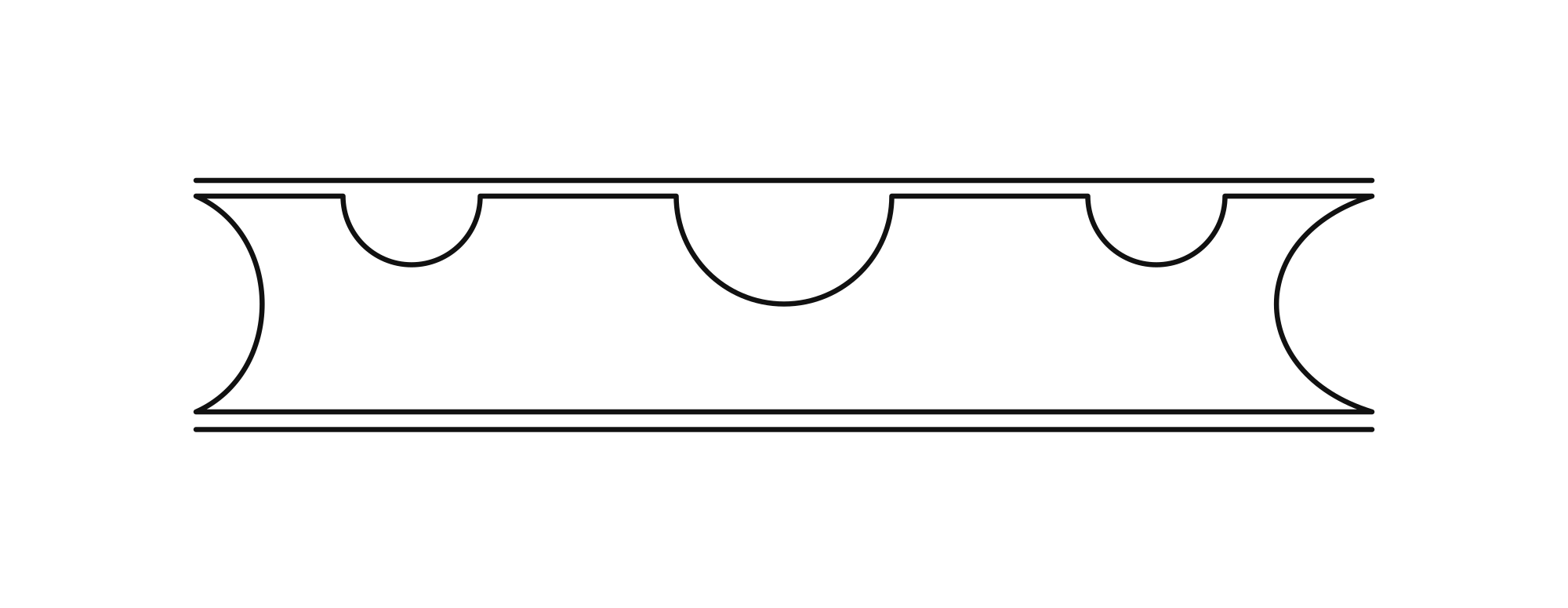
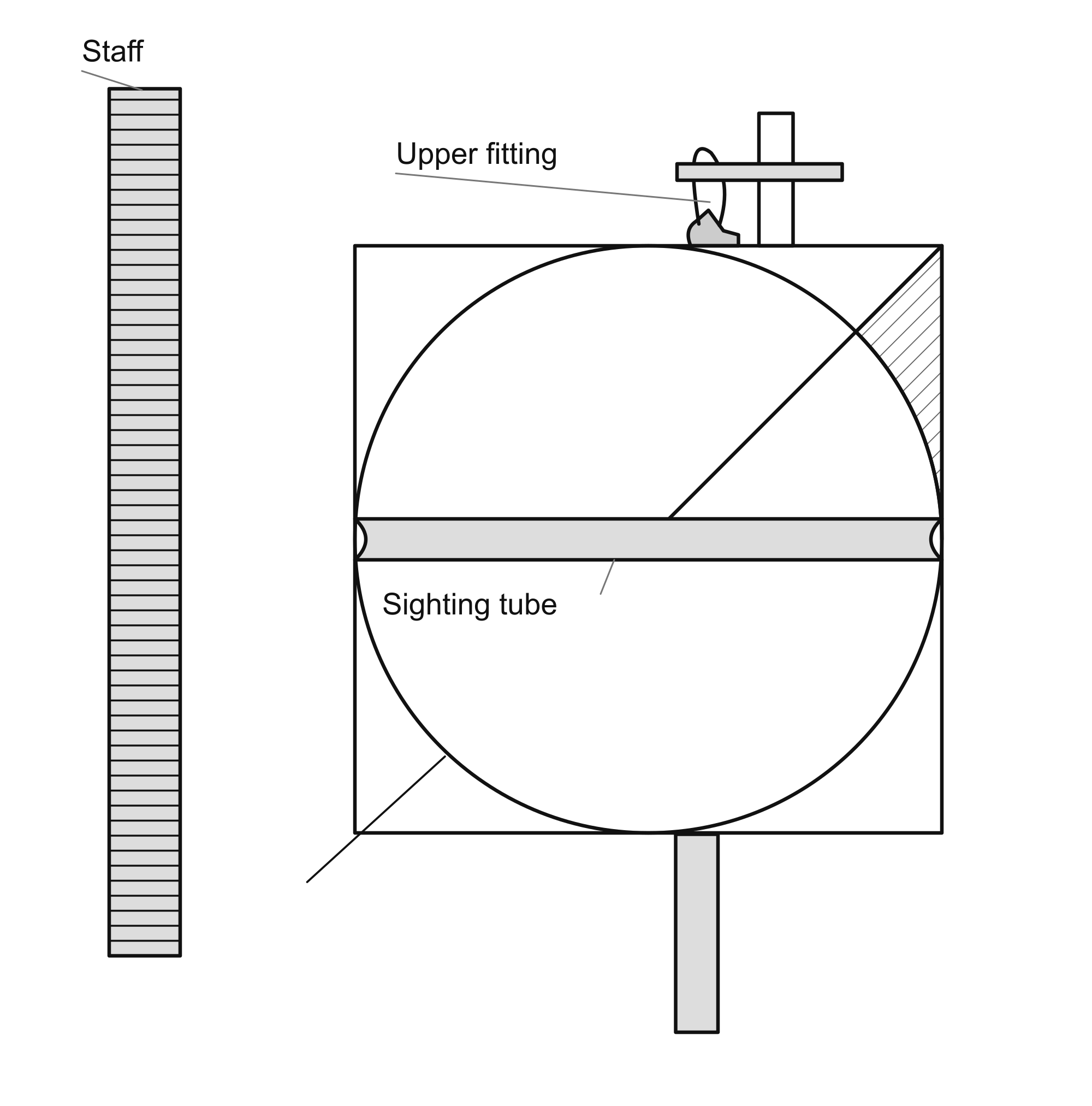
Measuring land for the passage of water means determining the relative heights of the places through which it is to pass. Several levels are used for this. One is a tube made of glass, hard wood or thick reed. It must be perfectly straight: a straight line along its surface should touch it throughout, and its diameter should be the same everywhere, without widening or narrowing at any point. Its length is a span and a half, or less, and its bore is approximately wide enough to admit the little finger. Its two ends are open, and at the exact middle it has a hole large enough to admit a fingertip. The three openings lie on one straight line.
Take two cords, each fifteen ordinary cubits long, or more or less as desired. They should be well twisted and smoothly finished, made of silk or flax, without roughness that would disturb the measurement. Fasten each one in …
Figure 1. Water-tube level. Water-tube level with three openings, completing the description on the preceding leaf. The manuscript’s schematic profile and curved ends are retained. (LJS 399, 23v.)
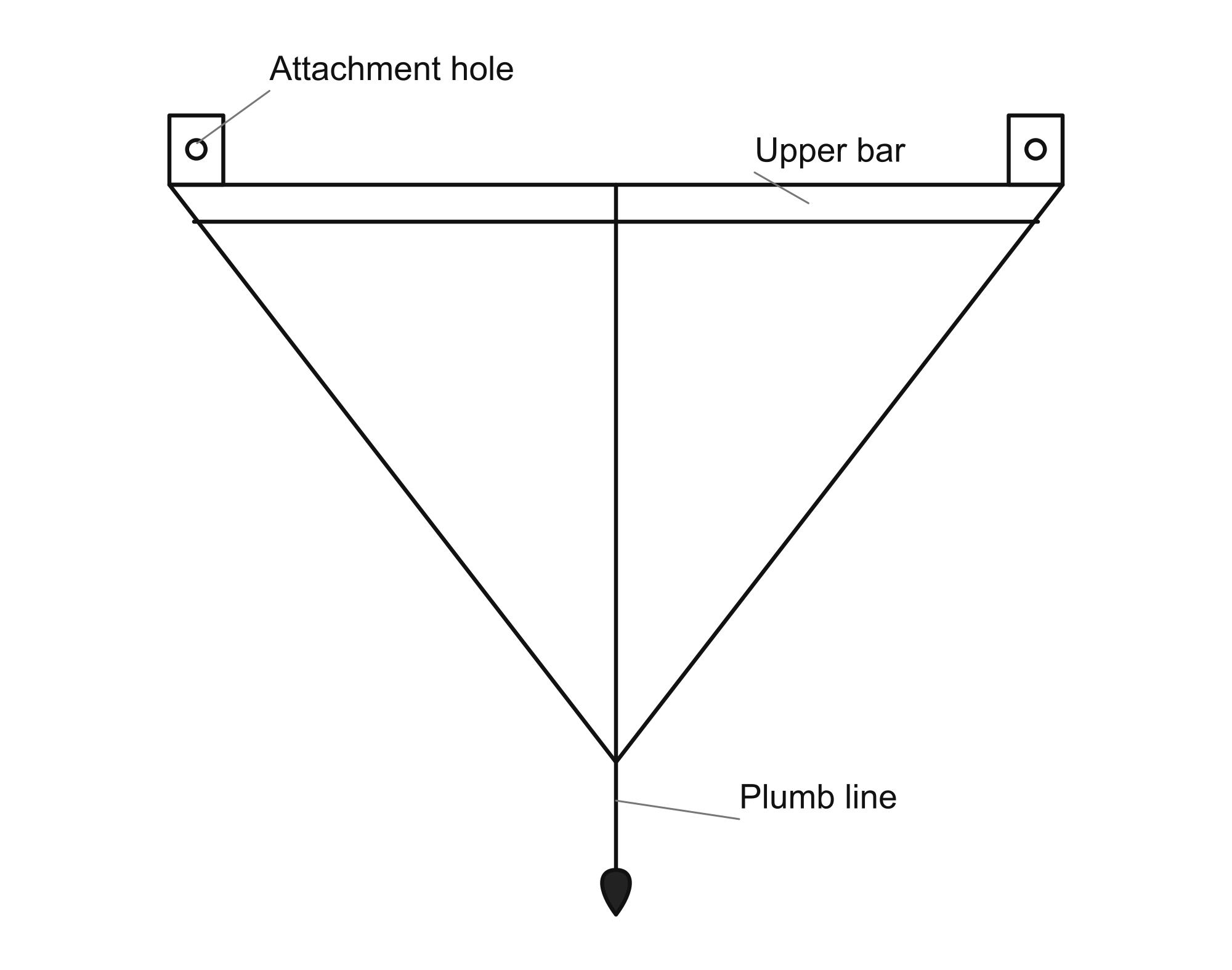
Another level is a plate made of brass or hard wood that will not warp. Make it as light as possible while preserving its straightness. It has two equal legs and, at the two ends of its base, two pierced lugs about half a finger high. A line drawn from the center of one hole to the center of the other must be parallel to the base carrying the lugs. On the face draw a line parallel to the base, as close to it as possible. Bisect this line and draw a perpendicular through its midpoint to the angle between the two legs. This perpendicular also bisects the base.
Bore a small hole where the perpendicular meets the base, and suspend a fine silk cord from it. The cord should be longer than the perpendicular by two fingers or more. Attach a brass or lead weight of a third of a dirham. Then take a cord thirty cubits long and place the plate at its middle, with half the cord on each side through …
Figure 2. Triangular plumb level. Triangular frame with two pierced end lugs, an upper bar, and a central plumb line continuing below the lower vertex. (LJS 399, 24r.)
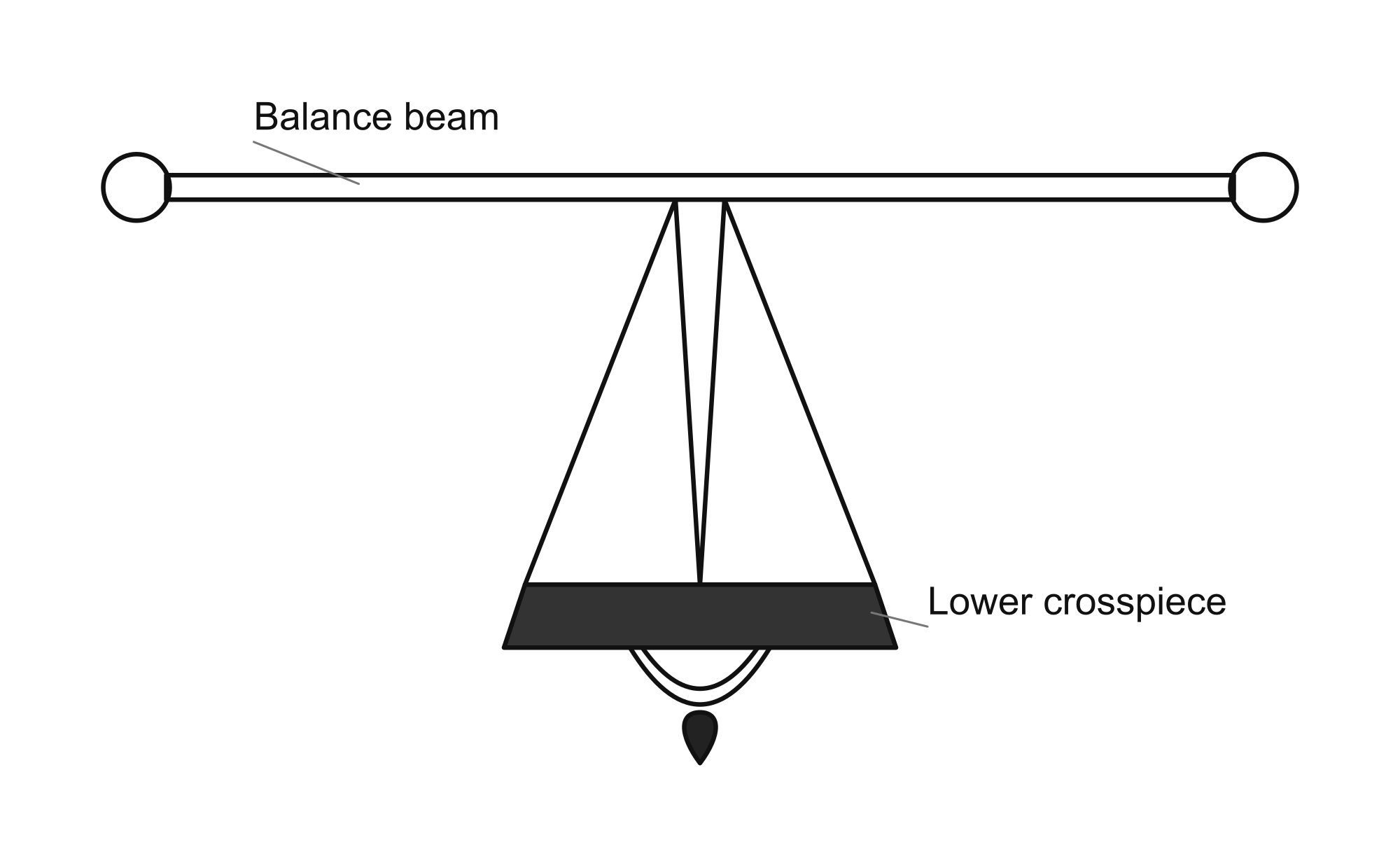
Another instrument is a balance beam. Make the iron beam as light as possible without allowing it to bend because the iron is too weak. Its tongue is also of iron. The beam is about a span and a half long, and the tongue a span or slightly less. Make its suspension fork light and fine. Hang a weight of about five dirhams beneath it, or suspend such a weight from a fine cord. The assembly must be perfectly straight and accurately fitted. At the two ends of the beam make two holes, passing a cord through each. This is its figure.
Figure 3. Balance-beam level. Balance-beam level with end holes, a central suspension and tongue, and a small weight below. The doubled curved line beneath the crosspiece is retained as drawn. (LJS 399, 24r.)
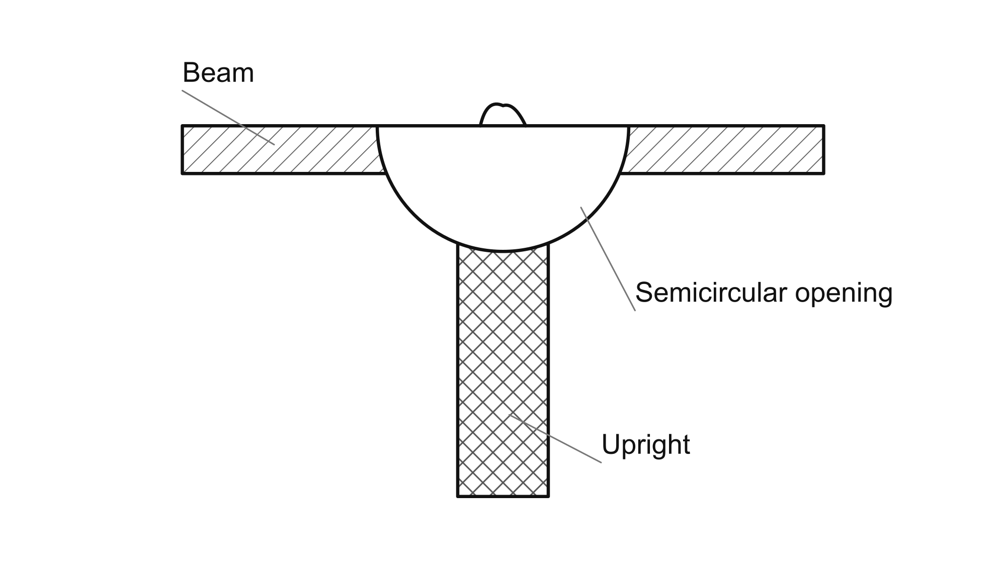
After this, take two wooden staffs, each six spans high or less, with their faces meeting at right angles. These are called the uprights. Have a man hold each one. Set one at the place from which you wish to begin measuring the ground and the other a cord's length away, using the cord on which the level is suspended. Stretch the cord moderately between the tops of the staffs. Each staff must stand perpendicular to the horizon. To establish this, suspend a fine plumb line from the top of each staff and keep it at the same distance from the staff above and below.
If the measurement is made with the water tube, carry a vessel of water and a piece of cotton. Wet the cotton and squeeze it over the hole in the middle of the tube, allowing drops to fall into it. If water comes out of both ends, the two stations are level. If it comes out of one end alone, the ground beneath the staff on that side is lower than the ground at the other station.
Tell the holder of the other staff to lower the cord along it little by little, while you continue putting drops into the tube, until water comes out of both ends equally. The cord is then parallel to the horizon. The distance through which it was lowered at the higher station is the difference in height. Preserve a measure of this with a cord. Then tell the holder of …
… the first staff to advance past the holder of the second. Again put drops into the tube and set the staff on the ground. If there is no difference in height, add nothing. Have the holder of the other staff advance in the direction you intend to survey, and make the measurement. If there is a difference in height, record it. Continue in this way until the qanat reaches the place intended.
If you began at the lower place, record each height measured on the advancing staff and subtract each height measured on the staff behind. The remainder is the height of the final station above the starting point. This is because the ground is not one level surface: it rises and falls, so differences must be measured in both directions. If you began at the higher place, record the differences in the same manner.
Measurement with the plate is like measurement with the tube. Its plumb line shows the difference in height toward one side or the other. If it inclines toward the staff on that side, that side is lower. Tell the man at the other end to lower the cord along his staff, little by little, until the plumb line lies on the perpendicular marked on the plate. Then measure and record the difference in height. Continue the work as already described.
As for measurement with the balance beam, the inclination of its suspension fork toward one side shows the difference in height: the station toward which it inclines is lower. Tell the man at the other station to lower the cord little by little until the tongue lies in the middle of the fork without inclining to either side. Record the difference in height and continue as already described.
I have seen a hollow glass tube with no opening except a hole in its middle. It had two lugs arranged so that a line from the center of one lug's hole to the center of the other was parallel to the inner surface. Along its length a line was drawn around both sides, parallel to the line through the two suspension holes. The plane enclosed by this line divided the hollow of the tube into two equal halves.
To measure with it, pour in water up to this longitudinal line. Place it in the middle of a cord thirty cubits long and stretch the cord between the tops of two staffs with moderate tension. If the water remains at the line on both sides, the two stations are level. If it rises above the line at one end of the tube, the station at that end is lower. Tell the man on the other side to lower the cord until the water coincides with the marked line. The amount through which the cord has been lowered is …
… the difference in height. Complete the leveling as already described. If each of the two staffs is divided into sixty parts, and each part is subdivided as far as possible, the heights can be recorded in writing. When the cord is lowered along the staff to a particular place, the number of parts and fractions through which it has descended is known.
Other levels
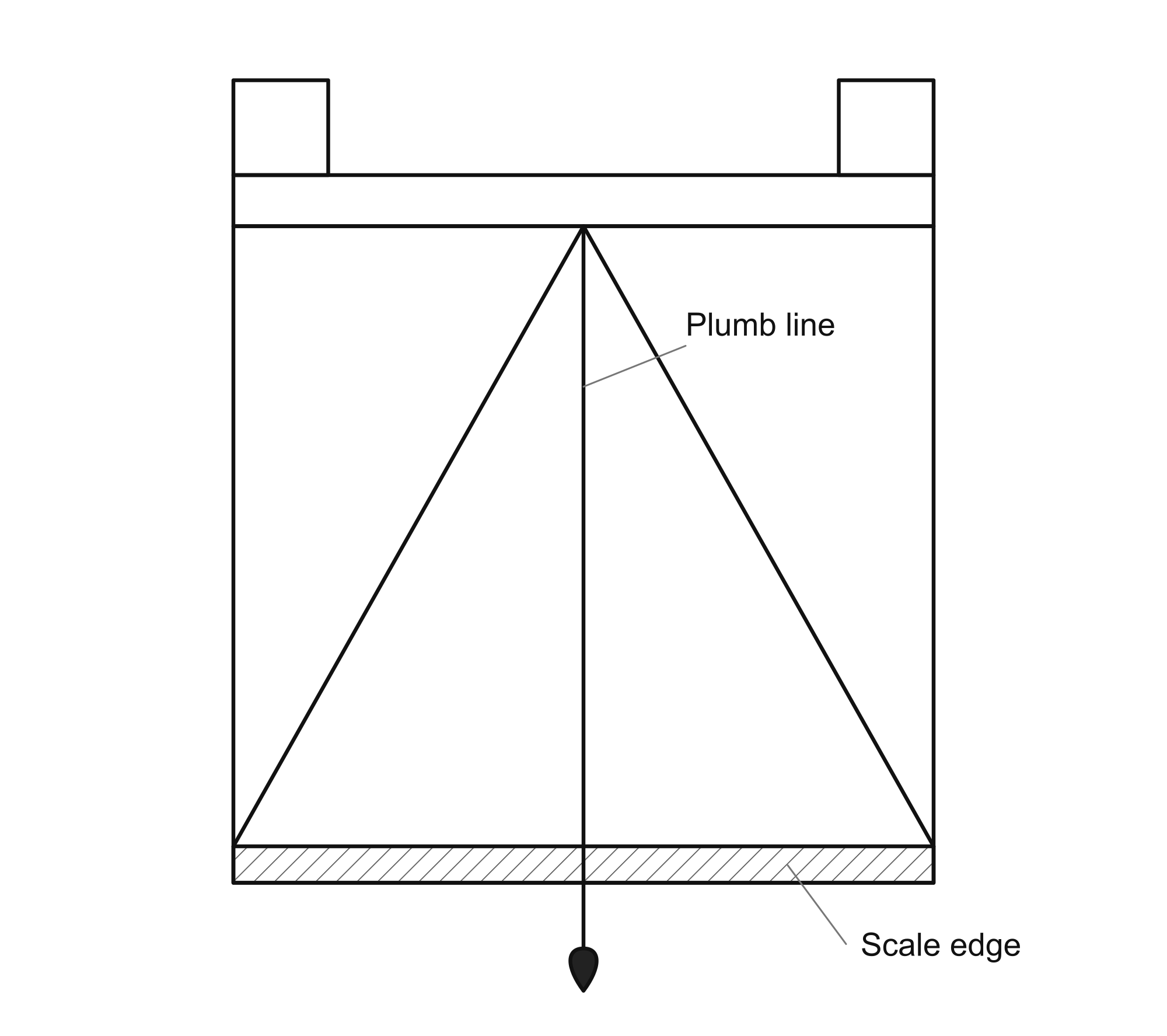
After this we say: if we wish to make a level that does not require the cord to be lowered, but shows the difference in height on the face of the instrument, construct it as follows. Make a four-sided plate of brass or wood, with two suspension lugs as already described. Near the upper edge draw a straight line and divide it in half. Bore a small hole at its midpoint. From the center of the hole draw a perpendicular to the opposite end of the plate. At the end of this perpendicular draw another straight line, meeting it at two right angles. This line lies along the edge opposite the edge carrying the two lugs, and is parallel to that edge. Suspend the plumb line from the hole. This is the figure of the level and its plumb line.
Figure 4. Plate level and plumb line. Rectangular plate with upper lugs, an internal triangle, and a central plumb line crossing the marked lower edge. (LJS 399, 26r.)
Let the rectangle forming half the plate resemble the rectangle bounded by an upright and the cord stretched from its top. It is preferable, however, for the ratio of half the longer line to the perpendicular to exceed the ratio of half the cord to the upright.
Make a chain of brass or iron in place of the cord. It must not stretch, whereas cords stretch readily. Have the metal drawn into sufficiently stout wire. Cut lengths of about a span, or somewhat more, turn each end into a small loop and join the pieces together. Soldering the loop joints is better and is not beyond the maker's skill. The finished chain is thirty cubits long. Divide each upright into sixty parts.
Choose two level places, neither higher than the other, separated by the chain's length. Set an upright at each, held vertical by an assistant, and fasten the chain at their tops. Suspend the plate at the chain's middle. When the uprights are correctly placed, the plumb cord coincides with the perpendicular drawn on the plate.
Then lower one end of the chain by one division along its upright. The plumb cord inclines toward that side of the plate. Mark the point where it meets the lower line, and continue …
… mark each place where the plumb cord meets the lower line. Let the divisions on one half of that line correspond to the divisions of the upright. Subdivide each division of the upright as finely as possible, for this gives greater accuracy. Having divided one half of the line in this way, carry out the same operation on the other half.
When you wish to measure, stretch the cord between the two uprights and suspend the level at its middle. Look where the plumb cord falls. If it coincides with the perpendicular, the two positions are level. If it inclines away from the perpendicular, read the divisions and fractions of a division through which it has moved; these indicate the corresponding divisions on the upright.
Great care is required in dividing the aforesaid line according to the divisions of the upright. The divisions of the upright are equal, but those on the line being marked are unequal. Each division of the upright nevertheless indicates its corresponding division on that line. The reason is that, when the measuring cord is lowered from the top of the upright to its foot, its end travels along an arc, not along a straight line, whereas the divisions of the upright lie along a straight line.
Let A–B–J–D be the rectangular surface, and let A–B be the measuring cord stretched between the two uprights …
… A–J is one upright and B–D the other. Divide A–J into six equal parts; it would also be permissible to use more or fewer divisions. With B as center and the length A–B as radius, draw arc A–F within the rectangle. At F draw a perpendicular to the line A–B; let it meet that line at H.
From the successive division points on A–J draw perpendiculars to H–F. Since H–F is parallel to A–J, H–F is thereby divided into six equal parts corresponding to the six divisions on A–J.
The line B–F represents the cord when its movable end has been lowered to the foot of the upright. At the midpoint of B–F draw a semicircle of any suitable radius, and from its center draw a radius perpendicular to B–F. Starting at the end of that radius, mark off a small arc similar to arc A–F. Join the end of this small arc to the center and extend the line until it meets A–B. I say that it meets A–B at right angles: this is the position of the level’s plumb cord in the construction.
To demonstrate this, the small arc and arc A–F are similar, and therefore the angles they subtend at their respective centers are equal. The angle formed by the extended radius and the diameter has its equal opposite angle …
… The two adjacent angles in the small construction together form a right angle. The equal angles in the triangle formed by the extended radius, the measuring cord and B–F therefore also total a right angle. Since the three angles of a triangle equal two right angles, the remaining angle is a right angle. Thus the extended radius is perpendicular to A–B.
Next I say that when the end A of the cord is lowered by the first of the six divisions on the upright, it travels along the corresponding part of arc A–F, as determined by the perpendicular drawn from the first division point. The plumb cord then reaches the first mark on the lower line of the level. Lower the end by the second division: it travels to the next point on the arc, and the plumb cord reaches the second mark.
Continue with the third, fourth and fifth divisions, and finally lower the end to the foot of the upright, so that it reaches F. The plumb cord then reaches the last mark. In this way the relevant half of the lower line of the level is divided into six parts.
The angles whose vertex is at the center of the small figure correspond to the angles whose vertex is B. Each angle of the first set …
… equals its counterpart in the second set, but the successive angles are unequal. The first angle of the fan at B is not equal to the next one. In the adjoining triangle the angle at the first intersection is greater than a right angle; its excess over a right angle is not equal to the corresponding deficit of the other angle. Hence the successive angles at B are unequal.
Since each angle at the center of the small figure equals its counterpart at B, the triangles whose bases lie on the lower scale line are respectively similar to the triangles whose bases lie on H–F. The successive segments cut by the rays on H–F therefore correspond to the successive segments on the scale.
The six divisions obtained by the perpendicular projections from the upright are equal, but the segments cut by the rays on H–F are unequal, and so are the corresponding divisions on the scale. This is what we wished to demonstrate.
I also say that, as the end A of the cord is lowered while B remains fixed, upright A–J moves closer to the other upright. At the first position its approach is the distance between the first division on the upright and the corresponding point on the arc; at each succeeding position it is the corresponding distance from that division to the arc. The same applies successively to the remaining positions …
… and at the final position the approach is the distance from the foot of the upright to F. The rectangular part representing half of the level’s plate is similar to the rectangle formed by the uprights and the measuring cord. This is the figure of the construction.
Figure 5. Geometric construction for calibrating the level. Calibration construction. A, B, J and D name the outer rectangle; the large arc ends at F, and HF crosses AB at H. Intermediate letters remain omitted where uncertain. The small fan retains the manuscript orientation, which conflicts with the proof’s perpendicular plumb-line condition. (LJS 399, 29r.)
If the plate is a semicircle, this is better, especially if unnecessary material is cut away from its middle, leaving the marked rim and the radius needed to show the perpendicular. Put the two suspension loops on its diameter and provide the support and hole for the plumb cord. Operation with this instrument is more accurate.
The improved surveying instrument
I have devised a level better than all the levels already described, easier to use and more accurate, provided its operator is skilled. Its construction is as follows.
Make a round or square plate of brass or hard wood, and bore a true hole at its center. Make a brass tube about a span and a half long, a little more or less, perfectly straight, with a bore the size of an awl. Mount it across the middle of the plate on a pivot turning in the central hole, as an astrolabe's alidade turns. The tube may be longer than the plate's diameter. Give the plate a loop with a suspension hook.
Make a very straight wooden support, about four spans long, with a projecting upper fitting from which the plate hangs. With the plate suspended and you sitting on your knees, the tube's opening should be level with your eye …
… when the tube lies across the plate. If necessary, lengthen or shorten the wooden support or its suspension hook until the arrangement is as described.
Next make a straight wooden staff of square section, as high as a man can reach with his outstretched arm—about nine spans. It must be perfectly straight, with smooth, even faces and no bend. Divide one face lengthwise into sixty parts, and subdivide each as finely as possible. Leave approximately a palm's breadth at the top outside the divisions, and the same at the bottom.
At the last division near the top make a red, white or black mark, or use any other color that serves the purpose. Its outline is circular and its interior filled with color. The mark should be appreciably larger than a dirham; the last division line cuts its diameter into two halves. Make a corresponding mark at the bottom, with the last lower division likewise passing through its center.
Make a collar that fits the square staff closely, without looseness. On the side of this collar facing the graduated surface …
… draw a mark like the ones just described. Color its interior also.
Take a tightly twisted silk or flax cord, thinner than an awl. Its length is a cubit or more; at a hundred cubits the marks described above can be seen distinctly. The distance depends on the observer's eyesight: he may be able to see the marks clearly through the tube from farther away. Make the cord as long as that viewing distance. Fit a ring at each end. One ring passes around the graduated staff, which slides freely through it; the other is held by the man stretching the cord. The level is the plate described above.
To take a level, hold the end-ring together with the instrument and stand at the starting place. Have your assistant carry the graduated staff away in the intended direction, to the cord's full length, with the other ring around it. Whichever of you stands higher puts his ring on the ground; the man at the lower place raises his end until the cord is approximately horizontal, as judged by eye. This may be determined …
… by a third man looking from beside the middle of the cord. When it is parallel to the horizon, the surveyor, if he is at the lower place, drops a stone from his end to the ground. He sets the foot of the instrument's support at the point where the stone falls, upright and leaning in no direction. If he is at the higher place, he sets the apparatus beside the end of the cord on the ground and lets the plate hang freely until it comes to rest.
He looks through the tube toward the graduated staff, turning the tube on its pivot until its bore is directed at the lower mark and that mark can be seen through it. This applies when his station is lower than the station he will occupy on the other side of the staff, a cord's length away in the direction of the survey. An experienced man can recognize a difference in height even on gently sloping ground. If his station is higher than that next position, he instead sights the upper mark.
He then moves to the other side, in the intended direction, one cord-length from the staff. One end of the cord remains around the staff; he stretches it along the survey line, or somewhat to one side of that line, keeping it approximately horizontal as already described. If …
… the end of the cord is in the air, drop a stone from it to locate the foot of the instrument's support. If the end is on the ground, put the support's foot there. Look through the tube toward the staff. Its holder sets its foot on the ground with the graduated face toward the observer.
Have the assistant move the collar up or down until the center of its colored mark is visible through the tube. Measure the distance between this center and the center of the fixed mark toward which the tube was directed at the first station. The result is the height of the higher station above the lower one—the two places where the instrument was set for the first and second observations. Record it.
Next have the assistant move on with the staff by one cord-length, and continue finding the rises and falls as described. On gently sloping ground, sight the middle mark on the staff. If the subsequent sight falls above it, the distance from its center gives the height of the second place above the first; if below it, it gives the reverse. Adding a third mark between the other two …
… makes the instrument more convenient for every kind of ground the operator may encounter. If the site is uneven and the staff-holder cannot stand a full cord-length from the surveyor while remaining visible, shorten the distance. But the first observation must use the same distance between the level and the staff as the second. Here is its figure.
Figure 6. Graduated staff. Graduated staff with two dark crosspieces and a circular fitting beside the lower half. The original red staff is shown in gray. (LJS 399, 32r.)
Figure 7. Circular sighting instrument. Circular instrument with a narrow rim and a sighting tube across its diameter, mounted in front of upright members and an upper crosspiece. Original red components are shown in gray. (LJS 399, 32r.)
Proof of this. Draw HY along the ground between the first and second stations, the places where the level is set for the first and second observations. Let BH be the distance between the ground and the center of the level—the circle described above. Let BA be the line issuing through the bore of the tube from B to the staff, and let ṬA represent the graduated staff.
For the second observation, place the foot of the level’s support at Y. Let KY be the distance from the ground to the center of the instrument, and KD the sight line through the tube. I say that DA is the height of H above Y.
To demonstrate this, draw ḤY through Ṭ parallel to the horizon, perpendicular to the lines JY and ḤB, which lie in the directions of the instrument’s upright support. Through D draw DR parallel to AB; through A draw AJ parallel to DK; and join RK.
The quadrilaterals BRDA and JADK are parallelograms, since BR is parallel to JK. They are also equal: AṢ, the perpendicular height of BRDA from its base BR, equals AM, the perpendicular height of JADK from its base JK. Parallelograms on equal bases and having the same height are equal.
The segments BR, AD and JK are therefore equal. With this established, RD equals DK, and DL is common to the two triangles. Their two corresponding sides are equal, and angle RDL equals angle LDK; triangle RDL is therefore equal to triangle LDK. Consequently angles RLD and DLK are equal, and each is a right angle.
Angle LṬY is also a right angle, so KR is parallel to ḤY. Thus RḤ equals KY, each representing the distance between the ground and the center of the level; hence RḤ equals BH. Add the common segment HR to these equal lengths: RB equals HḤ. But BR equals AD, so HḤ equals AD.
HḤ is the height of H above Y. Therefore AD measures the required rise. This is what we wished to demonstrate concerning the use of this level. Here is its figure.
Figure 8. Geometric proof for the circular level. The nearby central points S and L are distinct. B* and D* are restored from the prose. R follows the manuscript’s undotted ra-form, corroborated by the Hyderabad Arabic proof. H and Ḥ represent different Arabic letters. (LJS 399, 33r.)
Make the plate and fit the tube at its center as described. Make the staff as before, but put a single mark on its graduated face. When both supports stand on the ground, the center of that mark must have the same height above the ground as the center of the instrument.
To survey with it, set the tube on the line through the plate's center that is parallel to the horizon and bisects the plate. Sight the staff from whatever distance permits a clear view. If the line of sight falls at the center of its mark, the two places are at the same level. If it falls above the mark, the distance between the sighted point and the mark's center is the height of the instrument station above the staff station. If it falls below, that distance is the height of the staff station above the instrument station. Continue in this way to the end of the survey.
This method is preferable to the preceding one: it does not require a chain or a cord, and any distance is permissible. If the sight passes above or below the staff, have its holder bring it toward you, provided you are on the side from which the survey began …
… but if you are on the side toward which the survey is proceeding, move the instrument toward the staff, so that no ground is left out of the survey. The level must be accurately made and properly adjusted. Even the slightest distortion produces a serious error. In successive observations sight the staff once from one side and once from the other, keeping the surveyor equally far from the staff on the two occasions, whether that distance is short or long.
The instrument can also be made in another form. Make its plate square and let the tube turn about its center. Draw the largest possible circle with that same center. Provide its support, hook and suspension loop as described.
Take a square wooden staff about ten spans long. Put a mark on one face at the same height above the ground as the instrument's center when its support stands upright. Divide the staff from the mark's center to its top into sixty equal parts, and subdivide each as finely as possible. Below the mark lay off parts of the same size; there will be fewer of them there, which does not matter. When this is done, take a measuring chain …
… of the kind described above. Make it as long as the distance from which the graduated staff can be seen clearly. Choose two places at that distance, neither higher than the other. Set the level at one and the staff at the other.
Look through the tube at the staff's first division above the center of its mark. On the plate mark the point at which the line extending through the tube from the center meets the graduated edge. Raise the tube to sight the second division and mark its corresponding point. Continue one division at a time to the staff's top, transferring its sixty upper divisions to the plate. Divide the lower part of the staff with parts equal to those above its mark, and transfer those also, taking the greatest care.
Place a straightedge through the plate's center and each point just marked. Draw the portion of each line between the plate's edge and the circle. The tube's end will then indicate the corresponding division. Take care to make this accurately.
To survey with the instrument, stand at the starting point and send the staff-holder one chain-length away in the intended direction. Set both supports upright and direct the tube toward the staff's mark. If …
… the tube falls on the line parallel to the horizon, which passes through the center and divides the plate in two, the two places are at the same level. If its end falls below that line, record the divisions it indicates, taking the horizontal line as the beginning of the count. Look through the tube at the staff's mark and determine from the graduated edge how many parts separate the two levels. Here is the figure of the level and staff.
Figure 9. Circular level and separate staff. Circular level within a square frame, with a horizontal sighting tube, an oblique line, upper fitting, lower support, and separate staff. The upper right corner is hatched, as in the manuscript. (LJS 399, 35r.)
Marginal continuation: If the tube is above the horizontal line, its reading gives the lowering of the instrument station below the staff station. Continue by this rule until the survey reaches its intended end. Extend the divisions on the plate's upper half onto its lower half.
If you prefer to divide the instrument geometrically, there is an easier construction than the preceding one. Set the instrument opposite the staff, their distance apart equal to the chain's length. The center of the instrument is at the same level as the staff's mark, neither above nor below it.
The distance from the center to the mark, the line joining the staff's top to the center, and the portion of the staff above the mark form a right triangle. Construct a similar triangle on the upper half of the plate, considering it in its suspended position. One side is half the horizontal line that bisects the plate. A second is a portion of the plate's vertical edge facing the staff. The third joins the instrument's center to that edge; it forms part of the line from the staff's top to the center.
Having represented this triangle on the plate, divide its side on the plate's edge according to the upper divisions of the staff. The resulting divisions are equal.
Proof of this. Let a rectangle represent the plate of the level, and let the line …
[Continuing the construction from the preceding leaf:] BJ represents the staff; B is its marked point, and F the center of the level. F is neither above nor below B. Draw FB, representing the length of the measuring chain. Draw FJ from the center of the level to J, the top of the graduated staff.
YṢ is parallel to JB. Triangle FYṢ is similar to triangle FBJ: angle FYṢ is right, as is angle FBJ; the angle at F is common, and angle FṢY equals angle FJB.
Divide JB, the part of the staff above the mark B, into six equal divisions. More or fewer divisions may be used; the essential point is that the divisions of JB are equal. I say that the resulting divisions of YṢ are equal also.
For the proof, triangle BHF is similar to triangle YLF, so BH/YL = BF/FY. Likewise BD/KY = BF/FY. Hence BH/YL = BD/KY. Alternating the terms gives BH/BD = LY/KY. Subtracting corresponding terms gives HD/BD = LK/KY. But HD equals BD; therefore LK equals KY.
JṬ is one fifth of ṬB. Therefore ṢS equals one of its divisions, which is what we wished to demonstrate. The same proof shows the equality of SN and the remaining divisions of ṢY. Here is the figure.
Figure 10. Corresponding divisions in height measurement. Seven rays from F connect the far points B, D, H, Z, Ḥ, Ṭ and J to the near points Y, K, L, M, N, S and Ṣ. The proof divides BJ into six equal intervals; the manuscript sketch is schematic. The near upright extends above the rectangle to Ṣ. (LJS 399, 36v.)
… and the distance from your station to the summit of any mountain or any visible object, and the distance between two summits or two visible objects. It may also be used for leveling the ground.
Make a square plate, bored at its center for the tube's pivot. Draw a circle with that center, touching the middle of each side. Draw two diameters crossing at the center, with their ends at the circle's points of contact with the square. Attach a suspension loop at one end of a diameter.
Make the sighting tube as long as the circle's diameter. Give the part against the plate fine pointed ends, each ending sharply. Divide each of the two vertical sides of the suspended plate as described for the fifth level in the chapter on levels. Make as many fine divisions as possible, leaving a little clear margin at the edge.
Divide the horizontal line in the same units, beginning at the center. Divide each arm of the tube outward from the center into units equal to those on the sides of the square.
With an accurate straightedge through the plate's center and each division, draw a line inward from the graduated edge to the circumference of the circle …
… in the middle of the plate. Whenever the tube's pointed end falls on the circle, these lines show which division of the plate's edge it represents. Here is the figure of the instrument and its support.
Figure 11. Instrument for measuring heights. A circle inscribed in a square, with perpendicular diameters and hatched corners. The supporting staff stands to the right and a separate tube is drawn beneath the plate. (LJS 399, 37v.)
If you wish to determine the vertical height of a mountain, whether far or near—its height being …
… the line dropped vertically from its summit to the horizontal plane on which you stand, extended straight beneath the mountain; or if you wish to find your distance from its summit or any visible point upon it, first choose two stations at the same level.
Suspend the instrument from its support and set its foot at the station nearer the mountain. Direct the tube toward the summit, look through it, and mark the point indicated by its end on the graduated edge.
Then move to the other station in a straight line, so that the foot of the mountain's perpendicular and the two stations lie on one line. This is easy to arrange. Set up the instrument, sight the summit again and mark this second position of the tube's end.
Count and record the divisions, including fractional parts, between the two marks. Also record the divisions between the end of the horizontal line and the second mark. Measure and record the distance from the center of the instrument to the first mark; the divisions on the tube can be used for this after it is detached from the plate. Then determine the distance from the center to the end of the horizontal line …
… through its center parallel to the horizon, and retain the measurement. You now have four recorded distances.
Multiply the parts of the second elevation—the distance between the end of the horizontal line and the second mark—by the distance in cubits through which you moved. Divide the product by the parts of the horizontal line reckoned from the center. Call the result the first retained quantity, and keep its value in cubits.
Then multiply the measured distance from the center of the alidade to the first mark by the first retained quantity, and divide by the interval between the two marks. This yields the distance in cubits between the first station and the mountain’s summit. [The operation in this paragraph is restored from the explicit proof on 40r; the wording here is defective.]
Multiply this summit distance by the parts of half the line parallel to the horizon, and divide by the measured distance from the center of the instrument to the first mark. [This division is restored from the following proof; see the note.] The result is the horizontal distance between the first station and the foot of the perpendicular from the summit, on the plane through the station. Subtract the square of this distance from the square of the distance between the summit and the first station, then take the square root of the remainder: this is the mountain’s perpendicular height.
If you wish to find the distance between two objects that are both far from you, first determine the distance from a single station to each of them. Then mount the instrument flat on the top of a small wooden support, with its graduated face towards the sky; then place …
… the end of the tube on the line that bisects the instrument’s suspension loop. Turn the instrument on its support until you see one of the two objects through the tube. Fix the instrument so that moving the tube will not displace it. Then turn the tube until you see the other object and mark the position of its end.
On the face of the instrument construct two lines proportional to the two distances already found, enclosing the angle formed by the sight lines from the center to the two objects. Put one on the line occupied by the tube at the first observation and the other on the line you have marked. Join their ends with a line and measure it carefully in the same units used for the two constructed lines.
You now know its ratio to each of those lines. If you compare it with the longer, take that proportion of the distance between your station and the farther object; this is the required distance. If you compare it with the shorter, take that proportion of the distance between your station and the nearer object; the result is again the required distance between the two objects.
To demonstrate this, let A–B represent the mountain’s height and let J be the center of the plate in its first position. Let A–J be the line to the summit and J–B the line from J to the foot of the mountain’s perpendicular. We wish to determine these three lines …
… Let the measured straight line along which you move, in the continuation of the preceding line, be J–Ṣ. Let the line from center Ṣ to the summit at the second observation be Ṣ–A. The first sight direction is represented at the second position by Ṣ–R. The two squares represent the instrument at its first and second positions.
Triangles Ṣ–N–H and Ṣ–J–F are similar, and each is right-angled. Therefore N–Ṣ is to Ṣ–J as H–N is to F–J. H–N is known: it gives the second elevation from the end of the horizontal line through center Ṣ. N–Ṣ is known because it is half the divided line N–D; and J–Ṣ is known because it has been measured. Multiply H–N by J–Ṣ and divide by Ṣ–N to obtain F–J. Thus F–J is known in cubits.
Triangle A–J–F is also similar to triangle H–R–Ṣ. Here is the demonstration. Angle A–F–J equals angle F–H–N, since F–J is parallel to H–N. Angle F–H–N equals angle R–H–Ṣ. Also, angle B–A–J equals angle N–R–Ṣ and equals angle A–J–F, since A–B is parallel to F–J. Consequently angle A–J–F equals angle H–R–Ṣ; the remaining angle, J–A–F, is …
… equal to angle H–Ṣ–R. Thus triangles H–R–Ṣ and A–J–F are similar.
We wish to find A–J, the distance from point J, the first station, to point A, the mountain’s summit. F–J is already known in cubits. The parts of R–H, the interval between the first and second marks, have to their corresponding line F–J the same ratio that R–Ṣ has to A–J. Multiply the parts of Ṣ–R by F–J in cubits and divide by the parts of R–H: this gives J–A in cubits.
Triangle A–J–B is similar to triangle R–N–Ṣ. Therefore Ṣ–N is to Ṣ–R as B–J is to A–J. Multiply the parts of N–Ṣ by J–A in cubits and divide by R–Ṣ [corrected from R–N in this witness] to obtain J–B. Subtract the square of B–J from the square of A–J and take the square root of the remainder: this is A–B, the mountain’s perpendicular height.
These calculated distances are measured from point J. If you wish to add the amount required by this point’s height above the surface of the earth, that is readily done using what has already been explained. This construction has many further applications, and there are many kinds of levels; but I have confined myself to the intended purpose and kept the account brief. God is sufficient …
As for the demonstration of how to find the distance between two objects or the summits of two mountains, it is plain. On the face of the instrument you have constructed a triangle similar to the triangle enclosed by the two lines to the summits and the distance between the summits. You know the parts of every side of the small triangle, and you know the distances from your station to the two summits. The distance between the summits is therefore known through similarity. For in two similar triangles, if the sides of one are known and two sides—or even one side—of the other are known, the unknown side can be found.
Figure 12. Surveying from two positions. Surveying from near station J and far station Ṣ toward summit A. B is the foot of the height, and F lies vertically above J. R and H are the first and second sighting marks on the far plate. The source sketch places its ray near R, although the proof uses H; that schematic discrepancy is retained. (LJS 399, 40v.)
Building and aligning a qanat
When you have mastered what has already been explained and wish to construct a qanat, look for its site. The best places for qanats are in the lowlands between mountains …
… that remain moist, with snow on them continually or in winter, or a plain extending along the foot of such mountains. If you find a place of this kind, do not pass it by.
If you find a plain far from those mountains, with abundant green growth and the plants that indicate water, consider it. Water within such ground remains in a fairly constant state and scarcely diminishes when rain and snow are scarce. With the signs already described, it is easy to choose a place for the qanat.
Begin its construction when the water is least, in the months of Shahrīwar and Mihr. If the ground is not soft, make the underground passages longer and wider than usual. In soft ground, make the passage smaller and its floor rounded, not flat. Where water extends over a broad and lengthy area, with many springs, a qanat placed below it will be abundant in water, particularly if the ground inclines toward blackness.
When you have found a place that suits you, begin leveling from the intended mouth of the qanat and work uphill toward the place where you wish to dig the trial shaft. First estimate its position, then determine it by leveling according to the rule already given. Dig the trial shaft, and when you reach …
… the water, compare the depth at which it is found with the surveyed rise of the ground above the mouth of the qanat. Use the remaining difference as the basis for the qanat’s rise. If the trial shaft does not give the required level, continue the leveling farther uphill until you obtain the result described.
When you have found the trial shaft in this manner, extend the qanat so that its lower part lies in the dry ground and its upper part in the source. As far as possible, seek firm earth, not soft earth. If you reach foul-smelling soil while working in the dry ground, turn toward ground without that smell. The ancients forbade beginning a qanat in foul-smelling soil.
Keeping the underground passage even in dry ground and in the source
Most qanat builders I have seen who claimed skill left rises and hollows in the bed of passages dug in dry ground. Sometimes they made the passage wider than necessary. This is a great cause of damage to a qanat, especially in soft ground.
If you wish to keep a gallery in dry ground even, there are two cases. Either the well toward which you are digging already exists …
… in which case the gallery’s rise and fall can readily be kept even, or the well has not yet been dug.
To guard against unwanted rises and falls, take a squared wooden beam three cubits long, with each face four fingers wide. Fit an upright on it, about one cubit high, and suspend a weight from its top by a fine cord. At the foot of the upright, make a semicircular opening in the wood, so that the suspended weight can pass through it. Draw a line along the upright, perpendicular to the beam. This is its form.
Figure 13. Underground leveling instrument. T-shaped underground level: a squared beam, an upright, and a semicircular opening for the plumb weight. Hatching distinguishes the wooden members. The manuscript’s drawn orientation is retained. (LJS 399, 42r.)
Take the beam down to the bottom of the well, at the beginning of the gallery. Whenever you have dug a cubit, place the beam on the floor and examine the hanging cord. If it coincides with the line on the upright, the work is correct. If it inclines away, the excavation has risen or fallen; adjust it by the amount needed to return the cord to the marked line. Repeat this as the gallery advances …
… until you have dug a straight length of three cubits. Thereafter keep the floor even with the beam, as I have described, throughout the gallery.
You may also drive a peg into the roof of the existing passage and fasten a cord to it. As you dig, stretch the cord along the new length. Keep the distance between the cord and the roof constant. If the roof is farther from the cord at one place than the stated distance, you have dug too high there and must lower it; correct the opposite error in the opposite way. The gallery’s height should remain the same throughout.
A practiced qanat builder can keep a passage straight by eye after digging only three cubits. He looks back toward its entrance from one side. If part of the entrance becomes hidden, the excavation is wrong; he cuts toward the side that restores the view. This applies to upward and downward errors as well as those to the right and left.
A better device is a brass tube whose opening admits the ring finger. Its length should be a span …
… and a half. Fit a ring at each end and attach to them a fine iron chain, with equal lengths on the two sides. Join the two sides at a single ring. Each side should be a span and a half long. At their junction attach the ring by which the device hangs from a peg.
The tube must be straight, with its openings aligned. When hung, the line through the centers of its openings must be parallel to the horizontal plane. To test it, fasten the suspension to a piece of wood set upright fifteen cubits from a wall. Look through the tube and mark the point seen on the wall. Then turn the tube around and look through its other end. If you see the same mark, it is true; if you do not, it is not true. The equal suspension holds it in the required position.
Figure 14. Suspended sighting tube. Suspended sighting tube: two equal lengths of fine iron suspension join the tube’s ends to a common ring. The manuscript depicts the device sideways and draws the suspension as straight lines. (LJS 399, 43r.)
When you have finished this and wish to keep the gallery straight, dig a cubit and a half in the required direction. Suspend the tube from the middle of the roof and look through it toward the well from which you began.
Hang a small ball, about the size of a gallnut or larger, from the roof at the opposite side of that well. Its height above the floor must equal the height of the suspended tube’s opening above the gallery floor. Looking through the tube toward the starting well, bring the ball into the line of sight.
After you have dug farther, hang the tube from the roof of the new work at the same height and sight toward the ball again. If the ball appears on the tube’s line, the work is correct; if not, an error has occurred. Look to see in which direction the tube has departed from the ball. If the departure is upward, cut lower in the gallery; if downward, cut higher. Correct a departure to the right by cutting to the left, and one to the left by cutting to the right. In each case work in the opposite direction from the error.
… will avoid error when driving a gallery through dry ground toward a well, whether or not that well has already been dug.
If you wish to drive toward a specified well, stretch a cord above the ground from the starting well to the intended well. Let it divide the mouth of each well into two halves through its center. From it suspend two cords, spaced apart, into the starting well. Each should extend to within one cubit of the bottom.
Begin digging. Look back from the gallery at the two hanging cords with one eye. If the nearer cord hides the farther one, the direction is correct. If they appear apart, the excavation has departed from the line; move toward the side indicated by the farther cord, which is the more distant from you.
Once you have dug a length on this alignment, use the suspended tube as described. Let it hang so that the line through its openings follows the required direction, and hang the ball in front of it in the manner already explained. Continue digging by this sight line, and you will reach the intended shaft without error.
Work in the water-bearing part is easier than work in dry ground: the flowing water preserves the proper rise and fall. You still have to guard against turning right or left, since water can flow in a winding qanat as well as in a straight one. It is desirable that its water should …
… have the same depth from beginning to end, with the gallery following one direction. There should be no great fall in its bed: about one cubit in each parasang is sufficient.
Digging a shaft to a gallery that has bends and turns
If you have driven a gallery from a well, had to turn it aside from the intended direction, and now wish to find where to dig a shaft down to its end, take a good divider of wood or iron. The outer sides of its two legs must lie straight when placed on the ground. Take also a rule divided into any number of equal parts.
Go down into the well from which the gallery was begun. Stretch a cord from the middle of the well along the straight part of the gallery. Where a bend makes the cord touch the wall, drive in a peg and fasten the cord to it. From that peg stretch the remaining cord along the next straight part until it reaches the wall at the next bend. Drive in another peg and fasten it there. Continue through every turn, using a single cord long enough for the whole gallery.
At each peg the stretched cord makes an angle. Measure that angle with the divider and the graduated rule. To do so …
… place the divider’s joint beside the peg and open its legs until their outer sides lie against the two stretches of cord, to the right and left of the peg. Measure the opening on the graduated rule and record the number of divisions. In this way determine the first angle, the second, the third, and the rest.
Then measure the length of cord from the center of the well to the first peg, from the first peg to the second, and onward to the final peg at the end of the gallery—the point above which the new well is to be dug. Record the lengths of all these straight sections, taking account of how tightly the cord was stretched.
Now ascend. Transfer the two cords suspended in the starting shaft to a straight piece of wood laid across its mouth, so that the surface reference preserves the direction of the underground cord. Fasten the beginning of the measuring cord to the reference on that piece of wood and stretch it out over the ground to the same length as the first underground section.
At its end set off the same angle as the first angle below. Stretch the next section to its recorded length, then set off the second angle, and continue in the same way …
… until the cord has been laid out above ground as it lay within the gallery. The final point shows where to dig the new shaft.
This is the figure of the divider, the rule, and the cord stretched within the gallery.
Figure 15. Bent gallery and measuring tools. Bent underground route with successive stations A, B, J, D, H and W. The following text names the four angles and five straight sections. A divider and graduated rule appear beside the route. (LJS 399, 45v.)
Angle A–B–J is the first, B–J–D the second, J–D–H the third, and D–H–W the fourth. A–B is the first straight section, B–J the second, J–D the third, D–H the fourth, and H–W the fifth.
Protection and maintenance
Keep the qanat cleared and clean, especially where mud and waterweed collect. In winter, close the mouths of its shafts with bricks or stone slabs. If these are unavailable, make covers of clay and lay them over the openings.
It is better, when the qanat is first built, to construct a raised rim of brick or clay around each shaft. Pile the earth removed from the shaft and gallery around this rim, so that runoff will be kept away from the mouth. It does no harm for the surrounding earth to rise above the shaft’s head. This is an important means of keeping a qanat in repair: runoff often carries material into its wells and blocks them.
Each month send someone down to inspect the shafts and remove any earth or other material that has fallen in, in addition to clearing the qanat itself. Where a shaft lies in the course of a flood, raise its rim and strengthen it with bricks and with water-resisting clay piled around it …
… to keep out the water. If stones are available, build around the mound with them as well.
A qanat should not be built in flood courses or valley bottoms unless the ground is firm and solid. In soft ground the expense may consume the benefit. If only a little of the ground is weak, the passage may be supported with brickwork.
Where the qanat must cross a valley bottom and flood-water rises above the shaft mouths, so that raised rims cannot protect them, close the upper parts of those shafts with clay. First line them with brick or stone. As the lining rises five spans, bring it inward by two or three fingers, narrowing the opening. Lay stone slabs over the narrowed opening and pack clay above them up to the mouth. Alternatively, make a brick vault, using mortar of clay that still retains its original moisture.
Where pressure comes from the source or from the sides of a passage in earth that does not hold together, set fired-clay sections in it, large enough for a man to pass through. Make small holes around them so that water can enter through the sides.
… from the roof of the gallery or the mouths of the shafts. It may be blocked in part or completely, and the obstruction may be earth or a fallen stone. If the obstruction is small, it is easy to remove. Sometimes the running water opens it without further treatment, especially when the blockage is earth.
I say that if you clean the qanat as far as the obstruction and leave it for a few days, the water will often open it. It is better still to dig a hollow in the floor below the obstruction, so that the water can carry the loosened earth into it.
If this does not work, and water is standing high in the wells above the blockage, use the following method. Excavate toward the obstruction until about three cubits remain between you and the water. Take a stout pole more than three cubits long and fit a strong iron point to its end. With it open a passage four fingers wide through the obstruction to the water. Then ascend from the well: the current will enlarge the opening and clear the passage.
If the water is not standing high, enter the well containing the obstruction and remove earth until you reach material moistened by the water. Fit crosspieces into its sides to make places on which you can stand and move upward. Take a long wooden handle; the scraper fitted to it should be …
… a curved iron blade mounted on a long shaft. Pull out the earth a little at a time until the water opens a way. You need not remove it all: once the water has risen and begun to run through, it will clear what remains. If the obstruction lies in the middle of a gallery, dig a shaft from the surface directly above it. On reaching the obstruction, open it in the manner described.
Receiving work from the qanat builders
For new work, require the qanat to follow one direction and a consistent bed, so that its water has the same depth throughout. A greater depth in one place indicates a hollow or deviation. Excessive fall makes the water run swiftly and scour its bed, especially in soft ground, and this leads to destruction.
If one straight course is impossible, still require a consistent bed and an even roof, with the corresponding water depth maintained throughout the passage.
As for clearing and cleaning, the surveyor must inspect the qanat before work begins. He should go down through it and state what each section requires—whether removing silt, opening a blockage, or some other work. Agree on the builder’s payment for each stated measure of work, measuring it carefully by the cubit.
When the builder has finished clearing it, the surveyor must go down again and examine it from beginning to end. If he finds …
… that the work has met the agreed conditions, he should pay the builder. If it is deficient, deduct from the payment in proportion to the shortfall. These are the sound conditions for the work.
As for measuring the earth removed from the qanat, great unfairness can arise. A builder may gather mud and pour a bucket or two of water over it, so that it measures more. He may also leave the channel uncleaned and bring up earth from the floor or sides of the shaft instead. The surveyor must therefore inspect the qanat itself; careful oversight prevents such deception. To look only at the spoil and say, “This is a third of the measure, for which so much is due,” or “This is a quarter,” is neither prudent nor a proper inspection of the work.
As for supporting the passage with stones and bricks, I have already explained it. This is what I have condensed concerning the knowledge of extracting water. [By understanding it, you will recognize what I have omitted of lengthy explanation and fuller exposition.] I praise God Most High for His successive favors and abundant blessings upon me, and invoke blessings upon His Messenger Muhammad and his pure family.
The book is completed, with praise to God and His favor, and blessings upon the best of His creation, Muhammad, His Prophet, and his family.
I finished copying it on the fourteenth of Dhu al-Qaʿda in the year 1084 of the Hijra.
[Seal below the copying note; its legend remains unread.]
Supplement to the textual break
Translated directly from Kitab inbat al-miyah al-khafiyah, Hyderabad Arabic edition (1941), printed pp. 11–13 (digital PDF pp. 16–18).
This supplement supplies corresponding material from a separate Arabic edition at the textual break between LJS 399, folios 7v and 8r. All digitized Penn pages have been obtained. The cause of the break is not established, and this material is not presented as a recovered manuscript leaf.
The opening repeats the beginning of the Tigris anecdote on 7v to make the connection intelligible. The final sentences overlap the depth comparison at the start of 8r. The main translation retains the Penn sequence. The following translation is from the Arabic printed text, not from a modern French or English translation.
The Tigris and water beneath the ground
Printed pp. 11–12
In one year the Tigris rose, and the channels by which it entered the land were blocked to prevent flooding. The water in the river rose, and the water in the wells rose with it and overflowed until several houses were flooded. The river water was muddy and fresh, while the water from the wells in the houses was clear and salty. This occurs only in ground whose parts have no barriers and through which openings extend throughout, as described. The ground of Isfahan resembles it.
When water remains in due measure, neither exceeding what is sufficient nor falling short of it, the earth remains inhabited and free from calamities, devastation and drought. When water exceeds or falls short of that balance, habitation diminishes and devastation and drought follow. A flood of water comes from an abundance of vapors, the density of the air and the transformation of most of it into water. A flood of fire comes from a scarcity of vapors and moisture, the thinness of the air and its transformation into fire.
Another kind, [tawwab] water, comes from rain. It sinks through openings in the earth until it reaches a flat barrier and stops. If a qanat is made in this water, it flows according to its supply, then ceases when that supply is exhausted.
Description of mountains and rocks that indicate water
Printed p. 12
After what we have already said: black mountains with much moisture indicate water when their rock is mixed with clay. Green mountains come next in abundance of water, then yellow, then red, according to the ancients. Black mountains whose rock is soft and layered, with broad summits and large masses, have more water than others. Mountains with much hard rock have little water. An isolated mountain has no water, especially when its rock is abundant and hard, because snow does not remain upon it.
Groups of many connected mountains, stretching for parasangs across the earth, with ravines between them that shelter snow from heat until spring and summer, mostly contain water, whatever their color. Broad summits have more. If their vegetation is abundant and fresh, or if many trees shade them from the sun’s heat, they contain more water, especially on their slopes facing north.
Soft black rock occurring in layers in deserts and mountains indicates water. So does rock of differing kinds with many [surface marks]. White rock that sweats moisture indicates water. Upright rocks projecting above [the ground] also indicate it.
Description of ground containing water
Printed p. 13
One who does not recognize signs on the earth’s surface of water concealed within it is deficient in his craft. I have described signs which, when understood by the observer, are sufficient. I now say that all ground joined to the feet of the mountains described contains water. Where broad plains adjoin their feet, the parts nearer the center have the most water, reached at shallow depth, especially where the soil has many openings.
If the soil of these plains is alike, the water throughout has one character, differing only a little. Yet water in a place nearer the center is reached at a smaller depth than water in ground farther from the center, for water passes through all of it in one continuous flow.
Notes on this supplement
The opening and closing overlap are intentional. The final depth comparison corresponds to the beginning of folio 8r; the manuscript-based text then proceeds to vegetation and other signs.
The printed wording at the transition to the discussion of water in due measure is syntactically awkward. The translation gives the contrast between adequate, excessive and insufficient water without claiming to resolve every word at that transition.
Tawwab is a provisional reading of the printed technical name. Its vocalization and precise sense need linguistic review. The subsequent description is retained without substituting a modern hydrological category.
Parasang is a historical distance unit; no fixed modern conversion is imposed. The explanations of water, fire, rocks and mountains belong to the author’s historical account.
The printed term for marks on the face of rock is uncertain. “Surface marks” is a broad rendering; it does not identify a specific kind of fissure or texture.
Glossary
Apogee — In the historical astronomical passage, the point where the sun is understood to be farthest from the earth; retained within the author’s cosmology.
Barbakh — An earthenware conduit pipe, or a section of such piping.
Cubit — A historical length measure based on the forearm; no fixed modern conversion is imposed.
Dirham — A historical coin and weight unit. In the sighting-target description its size supplies a comparison; elsewhere it denotes weight.
Finger — A small historical length unit used for thicknesses, overlaps and instrument parts.
Folio — A manuscript leaf, with recto (r) and verso (v) sides.
Gallery — The underground passage that collects or conveys water in a qanat.
Harim — A reserved or protected area around a well, spring or qanat, discussed in relation to neighboring works.
Level — An instrument or reference used to compare heights and gradients.
Mann — A historical weight unit used in the mortar recipe; the stated ratio is preserved without a modern conversion.
Perigee — The point opposite apogee in the historical astronomical account, where the sun is understood to be nearest the earth.
Plumb line — A suspended cord and weight used to establish a vertical reference.
Qanat — An underground water-collecting and conveying system, usually consisting of a gallery and access shafts.
Qannā’īn — Specialist qanat builders.
Shaft — A vertical opening used to reach the underground gallery, excavate material or maintain the work.
Source — A water supply or feeding origin; the draft sometimes distinguishes it from the outlet called a spring.
Span — A historical hand-based measure of length.
Sweet water — Fresh or palatable water in the terminology of this text.
Traverse — A measured route made of successive straight sections and turns. The term is editorial in descriptions of alignment.
Trial shaft — An exploratory shaft or well sunk to examine water, ground conditions and relative levels before completing a qanat.
Notes on the translation
1v The opening praise is physically interrupted by a repaired hole; it has not been reconstructed from another edition. One short patronal wish remains uncertain. The author's name on this leaf reads Muhammad ibn al-Hasan, whereas the project's bibliographic form is Muhammad ibn al-Husayn al-Karaji; the manuscript reading is retained here. Direct collation removes the earlier unsupported claim that the patron specifically inquired into scholars' needs. Compared with Mazaheri 1973, p. 52. Return to text
2r The earlier draft inserted a second series of patronal titles that is absent from this leaf. The prayer is now translated directly, including the renewal of learning and removal of oppression. The natural philosophy is the author's historical account. Compared with Mazaheri 1973, p. 53. Return to text
2v The passage is an assertion about water seeking a spherical surface, not a rebuttal of an imagined objection. The three hypothetical states retain the manuscript's order and its unusual description of the flush-surface state. The divine-purpose paragraph and its list of necessities are restored directly from the Arabic. Compared with Mazaheri 1973, p. 54. Return to text
3r The opening completes the explanation on folio 2v; it does not describe land being raised by vapors. The unusual last terrain term has been rendered broadly as passages; its precise lexical form is not secure. The astronomical explanation belongs to the author’s medieval cosmology. Compared with Mazaheri 1973, pp. 54–55. Return to text
3v Kadhdhan is retained as a traditional stone name rather than assigned an unverified modern mineral identification. The body analogy is to nerves and arteries. The final sentence continues on folio 4r with snow and island springs; the manuscript does not support the former draft’s claim here that the earth is not hollow. Compared with Mazaheri 1973, pp. 55–56. Return to text
4r Direct collation recovers islands with freshwater springs, the contrasting northern and southern sources, and the Nile example. The old draft's account of frozen northern rivers and snow persisting on shaded slopes is absent. These are the author's historical explanations of river supply and seasons. Compared with Mazaheri 1973, p. 56. Return to text
4v The earlier draft's Nile passage and explicit rejection of the philosophers are absent from this leaf. Direct collation distinguishes the philosophers' account of vapor rising to a summit from the subsequent account of snow-fed collection in loose soil. Compared with Mazaheri 1973, pp. 56–57. Return to text
5r The village spelling is represented provisionally as Kanda; its vocalization is not fixed by the manuscript. The bitter spring, its three openings, and its purgative effect are directly attested. The author’s rejection of seabed upwelling is preserved as a historical argument, even though a later passage describes collecting deep water. The objection about spherical form continues on folio 5v. Compared with Mazaheri 1973, pp. 57–58. Return to text
5v Direct collation restores the hypothetical cube and other solids bounded by plane surfaces, the balance of opposite weights, and the counterfactual of loose particles. The old discussion of surrounding air supporting the earth is absent. This is the author’s historical natural philosophy. The bracketed closing clause continues onto 6r with the word earth. Its causal sense is restored provisionally after checking both TIFFs and the Hyderabad Arabic edition, printed p. 8. The exact philosophical force of attaining its form remains uncertain; no modern explanation of spherical equilibrium is silently supplied. The earlier unsupported irregular-surface bridge remains withdrawn. Comparison: Mazaheri 1973, p. 58. Return to text
6r Direct collation replaces the old unsupported explanation by rising vapors and collapsing cavities with the author's examples of buildings, crumbling mountains, loose earth, and accumulated water disturbing equilibrium. The sentence continues on folio 6v with “of the equilibrium just described.” Compared with Mazaheri 1973, pp. 58–59. The opening bracket completes the qualified restoration begun at the end of 5v. Hyderabad, printed p. 8, supports the causal connection; the philosophical force of attaining its form remains uncertain. Return to text
6v The remaining opening and descriptive word have been recovered. The opening continues the preceding leaf’s statement that the earth moves in pursuit of equilibrium; it reads “the equilibrium just described.” The source description reads sakin, residing or resting, not an unknown technical term. The phrase “God knows best concerning this,” previously omitted, is restored after the astronomical claim. The astronomical statements and the account of water arising from air are the historical author’s claims. The first-pass corrections to meridians, the 18,000-year interval, the rate of one degree per century, and the connected interstices are retained. Direct collation used the full-resolution master for 6v and the preceding 6r image. Comparison with Mazaheri (1973), pp.59–60, corroborates equilibrium and residence, but his wording is not used to supply extra text: https://www.persee.fr/doc/page/epide_0768-5289_1973_edc_6_1_885/epide_0768-5289_1973_edc_6_1_T2_0059_0000 . Return to text
7r The apparatus is now recoverable: a perforated lead vessel, a long watertight leather tube, and a fitted ball plug operated by a cord. No vessel shape, numerical depth, or second lowering is specified. The claim of obtaining fresh water from the sea bottom is the author's historical report. Compared with Mazaheri 1973, p. 60. Return to text
7v A repaired hole partly obscures the word for water entering the sampling vessel; the surrounding instruction is legible and the supplied noun is bracketed. The apparatus is withdrawn once by its handle cord; the old second immersion and weight are absent. A textual discontinuity occurs between folios 7v and 8r: this leaf ends during the Tigris-flood example and has the catchword al-abar (the wells), while folio 8r begins a later passage about depth relative to the center. Both TIFFs are present, and the catalogue labels the digitized leaves consecutively. The cause and physical extent of the discontinuity are not established. The separately labelled supplement translates corresponding material directly from the Hyderabad Arabic edition, printed pp. 11–13, with explicit overlap at both boundaries. It is external textual evidence, not a recovered Penn leaf. Comparison: Mazaheri 1973, pp. 61–63. Return to text
8r Direct collation recovers dew and mist rather than the old unsupported stone colors and insects. It also restores the warning that wind in empty ground may imitate a water sound, and the named intermittent spring near Nahavand. These are the author's reported signs and observations. Compared with Mazaheri 1973, pp. 63–64. The final sentences of the separate Hyderabad supplement overlap this folio’s opening depth comparison; the manuscript-based text here is retained. Return to text
8v Plant names are retained in transliteration because historical vernacular names do not securely establish modern species. The manuscript's ʿallaq/lif gloss and the name qurras remain lexically uncertain; no species identification is supplied. The Tigris-bank anecdote contains an unresolved measurement. The Hyderabad Arabic edition, printed p. 14, gives more than fifteen cubits; Mazaheri 1973, p. 65 gives fifteen. Neither reading establishes the unclear Penn numeral, and neither is imported into the translation. The separate well anecdote explicitly gives fifty cubits, correcting the old twenty. The brief cultivation clause is preserved without importing the additional melon-grafting instructions in the comparison editions. Compared with Mazaheri 1973, pp. 64–66. A fresh inspection of TIFF 0234_0017 still did not justify fifteen in the Penn reading. Return to text
9r Direct collation confirms white mountains, not red. The author expressly claims that sufficiently deep excavation ultimately reaches water unless impeded; the previous draft inverted this claim. The text states the author's historical generalizations rather than endorsing them as modern surveying rules. Botanical names continue the conservative transliteration used on 8v. Compared with Mazaheri 1973, p. 66. Return to text
9v The manuscript announces three kinds and then introduces water supplied by the transformation of air without an explicit second-category numeral, before saying “the third.” This transition is preserved without adding a missing number. The earlier references to water becoming stone, hot and cold springs, and rainwater being the finest are absent from this leaf. The final corruption clause continues on folio 10r. Compared with Mazaheri 1973, p. 67, which also notes the numbering irregularity. Return to text
10r Several words in the middle of this leaf are rubbed. Secure readings distinguish seepage from the sides from strong sources at the qanat floor, and describe water issuing on all sides as excavation deepens. The connecting clause about the source and its supply, and the exact characterization of water whose point of issue descends, remain unresolved. The reading sinks follows the visible verb inhatta, rather than substituting ceases. Mazaheri 1973, p. 68 gives a more continuous practical explanation; its added warning not to rely on side seepage has not been imported. Ma’ al-tawwab is the traditional retained-water term also used on folio 5r. Mineral names are historical categories, not modern purity assessments. Return to text
10v The passage describes historical criteria, not modern drinking-water guidance. The manuscript says loose earth in the clause about saline water that solidifies in air; Mazaheri’s discussion of a soluble rock is not substituted. The final comparison continues on folio 11r with weighing equal quantities; no cooking test occurs here. Compared with Mazaheri 1973, pp. 68–69. Return to text
11r Direct collation identifies earthenware vessels, not wetted cloth, and recovers percolation and settling tests. The old evaporation and chickpea-cooking tests are absent. The treatment ingredient is tin hurr, pure or potter's clay, not burned clay; no boiling is prescribed here. The passage is translated as a historical account of water assessment and treatment. Compared with Mazaheri 1973, pp. 69–70. Return to text
11v The old autumn increase and spring cessation were mistranslations. Penn explicitly places the strongest supply in spring. The passage's argument concerns the seasonal conditions of cultivation and habitation, not only the quantity of qanat water. Its historical theory of air becoming water is preserved. Comparison: Mazaheri 1973, pp. 70–71. Return to text
12r The full four-season sequence of zodiacal signs is recovered. The final equatorial comparison is shorter and less regular in Penn than in Mazaheri 1973, p. 71, which explicitly gives both equinoxes and both solstices. The English does not silently add Libra or Cancer to Penn's final sentences. The final count of two of each season is legible. This historical account is not modernized. Return to text
12v The earlier discussion of adding a clay lining and varying channel width did not represent this leaf. The argument is about preserving the natural moisture of clay during excavation. The Persian-derived name for the water-bearing test excavation is rendered by its function; its exact transliteration remains unresolved. The following leaf completes the observation on firm soil. Comparison: Mazaheri 1973, p. 72. Mazaheri’s commentary, pp. 150–151, identifies the corresponding Persian-derived term as al-kumanagah and explains the trial-well function; this corroborates the functional English without establishing the exact spelling of Penn’s word. Return to text
13r The pit depth is securely three cubits or more; the covering is green leaves of any kind. The fire dries the pit before the cup is installed, rather than functioning as a separate flame-response test. The suspended-wool test lasts three daytime hours, optionally a whole night, and specifies oil. The final alternative material continues on 13v. These are reported historical prospecting tests. Compared with Mazaheri 1973, p. 73. Return to text
13v The opening “cloud” translates the Arabic gloss of a Persian name for an absorbent material; Mazaheri identifies it as sponge. That identification is comparative, not an explicit Arabic naming of sponge. The main section explains the movement of springs by earthquakes and trapped vapor; the previous draft's warming-bottom and cooling-air account is absent. The last section introduces joined lead pipes, not a claim that cold air forces water upward. Compared with Mazaheri 1973, pp. 73–74. Return to text
14r The cup of justice and bent glass siphon are explicit examples in the manuscript. The old draft's account of a shock opening a channel reversed the stated cause: a collapse blocks the qanat and water accumulates. The figure of fifty cubits concerns water height in the shafts, not their spacing. Comparison: Mazaheri 1973, pp. 74–75. Return to text
14v The sealed millstone and lead tube are recovered. The last paragraph permits two outcomes—greater flow or loss of the spring—rather than guaranteeing an increase. This corrects the old generic instruction to stop at a required opening. Comparison: Mazaheri 1973, p. 75; its explanation of the excavation's possible loss of water is not substituted for Penn's wording. Return to text
15r These are medieval juristic opinions reported by the author, not a statement of present-day law. Direct collation corrects the name to Muhammad ibn al-Hasan and recovers the competing permission rules, liability exception, joint-ownership condition, and access rule. The term qanat is retained; nahr is translated watercourse. Cubits remain unconverted. Compared with Mazaheri 1973, pp. 76–77. Return to text
15v The passage reports medieval legal opinions and prophetic reports without independently authenticating their attribution. The manuscript's positive statement that the canal owner has a benefit in the bank is logically awkward in Abu Hanifa's argument; it is preserved, not silently supplied with a negation. Mazaheri 1973, p. 77 likewise flags that clause. The rope-length qualifications, land-revival dispute, and bank/spoil distinction are recovered from the Arabic. Return to text
16r The repeated figure is five hundred cubits, not the former one thousand. The old two-hundred-cubit rule is absent. The last figures are five and seven cubits between a well and a cesspit; they are not an unfinished measure for rivers. The more-than-five-hundred-cubit no-harm reply has a compressed introductory formula, which is not silently reconstructed from the French. These are reported medieval opinions, not current legal guidance. Comparison: Mazaheri 1973, p. 78. Return to text
16v The manuscript says porous or open-textured soil, not hard impermeable ground. It gives Iraq and the Tigris and Euphrates as its first example. The specified thousand cubits is the sum of two five-hundred-cubit reserved areas for parallel qanats at the same level. These are the author's historical hydraulic and legal arguments. Comparison: Mazaheri 1973, p. 79. Return to text
17r The first forty-unit interval uses a historical measure whose exact name remains uncertain; it is not the word for cubit. The Hyderabad Arabic edition also has a different unit here, and the French edition interprets it as a fathom-like measure. No fixed conversion is imposed. The later forty-cubit interval on this same folio is distinct and is retained. The earlier anecdote about discovering a broken ancient qanat is unsupported and has been replaced. The observation is of a broad desert, not a rock face: deep water in the plain contrasts with wells on a raised site. The trusted informant’s account continues on 17v. These are historical arguments about groundwater and legal protection. Return to text
17v The opening completes the two-qanat anecdote on 17r. The new case begins in open land, not hard ground; it gives one thousand cubits, not “water far below the surface.” The legal same-level rule is distinguished from the case in which a mountain separates the channels. The final lower-level case continues on 18r. The phrase about the law’s alternative rational grounds is compressed in this witness; the translation retains that limited claim rather than expanding it into an explanation absent from the text. Return to text
18r The initial comparison is between qanats whose water stands at the same level; the former draft mistakenly made the new source lower. The midpoint test, the author's inference from unequal water levels, and the second test well are retained as a connected historical argument. The decision in the final sentence continues on folio 18v. Comparison: Mazaheri 1973, p. 81. Return to text
18v The opening completes the second test-well case on 18r: an unequal level does not justify preventing the new excavation. The thousand-cubit total consists of two five-hundred-cubit reserved areas. The later permission to prohibit a lower qanat is conditional on the absence of the intervening comparison well. The text distinguishes legal protection against building or cultivation from tests of hydraulic interference. Seven cubits, not an unspecified interval, closes the discussion of watercourse banks. The new chapter names underground vapor; the draft’s mountain-height obstacle is unsupported. Return to text
19r The fire-setting passage names strong-burning woods, fruit wood and naphtha. It does not specify cooling or quenching the heated rock. The lateral cavity is for moving an obstructing stone, not diverting water. The unstable-soil categories are restored without the draft's unsupported air cavities. The boards are to be as wide as can be found; the manuscript phrase is corroborated by the Hyderabad Arabic edition. No numerical width is supplied. Botanical ghada is retained without forcing a modern species identification. Comparison: Mazaheri 1973, p. 82. Return to text
19v The cubit and cubit-and-a-half measure belongs to earthenware pipes, not the height of the timber frames. “Across” makes the implied pipe dimension explicit; the manuscript gives the dimensions without separately naming a diameter. Iron fastenings, the permanence of fired clay and washing the clay are restored. The old instructions to remove the timber or avoid striking with a pick were not supported by this leaf. Comparison: Mazaheri 1973, p. 83. Return to text
20r Direct collation restores the fourth climate, the Isfahan pipe method, and the tapered masonry passage. The dimension assigned five spans is uncertain; the earlier tentative length gloss has been removed. The Hyderabad Arabic edition, printed p. 31, uses a word for opening and gives the width in relation to the gallery. Penn has three spans high followed by width “half of it,” whose exact antecedent remains uncertain. These readings do not justify silently imposing a length or a modern pipe diameter. The masonry passage’s separate dimensions are secure: three spans below and two and two-thirds above. Mazaheri 1973, pp. 83–84 was consulted for comparison; its simpler five-span length and three-span width statement does not replace the more complex Penn wording. The closing flow instruction continues on folio 20v. Return to text
20v Bukhar (literally “vapor”) denotes the foul or suffocating underground air discussed by the author; it is not identified as a single modern gas. The earlier draft incorrectly made the section about water preventing excavation and placed the maximum in summer. The manuscript says midday. The Isfahan passage describes raised curved rims around individual pipes; their exact molded profile is not recoverable from the prose alone. The water-lifting implement is rendered functionally as a scooping device rather than a modern pump. Return to text
21r This leaf records the author’s historical explanations and measures for underground vapor. The translated remedies are retained as statements of the medieval text. The hide tube, its connection to bellows, and continuous blowing during the worker’s presence are explicit. The manuscript says to widen the shaft at places; it does not specify square resting niches. No particular melon variety is named in this copy. The phrase describing the ancient authors’ preferred lamp fuel does not erase the preceding list of fuels. Return to text
21v The first section concerns leather clothing for a strong spring or steep watercourse, not an interception channel. The two-finger overlap and length of four times the wider opening’s diameter are explicit. The copy commends longer pipes because their clay lasts longer; no numerical service life is supplied. The narrow end has a thinner wall than the wide end. The precise tailoring of the overlapping hood and shirt neckline is compressed in the copy; the functional overlap is secure. The final sentence continues on fol.22r. Return to text
22r The manuscript specifies twelve mann of lime to one mann of oil, a vent every hundred cubits, and a wait of at least three days. Mann is retained as the historical unit of weight. The earlier draft omitted the lime-to-oil ratio. The final sentence continues on the next leaf. Return to text
22v Iron dross translates khubth al-hadid; its precise metallurgical composition is not specified. The change from brick lining to a clay bed is compressed, so the supplied words “with clay” are marked. The manuscript expressly describes livestock trampling the channel bed. Mazaheri’s French comparison (1973, p. 88) instead gives a fresh-dung mixture; that different recipe has not been substituted for this witness. The final ingredient, slaked lime, follows on the next leaf. Return to text
23r The first instrument is a water tube, whose figure follows on folio 23v. It has two cords of fifteen cubits each, not a single fifteen-cubit cord. The bore comparison reads khinsir, little finger; the French comparison gives the ring finger. The central opening admits a fingertip: the old one-sixth-finger dimension was a misreading of ra's isba'. Comparison: Mazaheri 1973, pp. 88–89. Return to text
23v The figure at the top completes the preceding water-tube description; the plate is introduced in the words around it and illustrated on folio 24r. Direct collation restores the triangular plate's two equal legs. The close parallel line, midpoint, vertex and perpendicular are construction references, not an instruction to cut the timber away. Brass or hard wood is specified, not bronze. The weight is one-third of a dirham and the suspension cord thirty cubits. Comparison: Mazaheri 1973, pp. 89–90. Return to text
24r The material is iron, not bamboo or wood. The opening instruction balances lightness against bending from weakness of the iron; it does not name a prototype balance. This reading is supported by the manuscript and Hyderabad Arabic edition. Penn gives a beam about one and a half spans long and a tongue about one span or slightly less. Hyderabad instead makes the tongue the same length as the beam; that variant is recorded but not substituted. The plumb weight is approximately five dirhams. Mingam denotes the balance’s suspension fork or stirrup; the drawing is redrawn without inventing a mechanical attachment. Comparison: Mazaheri 1973, p. 90. Return to text
24v The manuscript describes the water-tube method specifically: a water vessel, wetted cotton and drops through the central hole. The end on the higher, dry side is lowered. The old instructions involving sights, a suspended plumb-level reading, equal staff divisions and a mark on the ground were unsupported here. The six-span staffs are explicit. Comparison: Mazaheri 1973, pp. 90–91. Return to text
25r The page gives successive-station accounting followed by the plate-level procedure. It does not contain the old draft's long warning about sag, unequal attachments or a promised proof. The plumb line's inclination identifies the lower side; the cord is lowered on the opposite staff. Comparison: Mazaheri 1973, p. 91. Return to text
25v This is a closed glass tube with one central opening, distinct from the open-ended tube of folio 23r. Its reference line divides the interior into equal upper and lower halves. In both procedures the cord is lowered on the opposite, higher side; the previous draft incorrectly raised the lower end. The balance's fork and tongue are distinguished. Comparison: Mazaheri 1973, pp. 91–92. Return to text
26r The rubric says “Other levels.” The first staff division is sixty parts, with further subdivisions. The construction specifies two parallel lines and their central perpendicular; the oblique lines are visible in the drawing but are not separately constructed in this wording. No equal division of the lower scale is stated here. The marginal continuation beside the figure is included. Comparison: Mazaheri 1973, pp. 92–93. Return to text
26v The missing length concerns the finished chain: thirty cubits. Sixty is also the number of divisions on each upright. The draft had confused wire-link construction with tiny marks on the plate and had raised the rod instead of lowering the chain end along it. Penn compares the plate with half the cord in its opening proportional clause; Mazaheri 1973, p. 93, renders a full-chain comparison and discusses the resulting shape in a footnote. The source's half-cord wording is retained. Comparison also pp. 93–94. Penn does not specify sixty wire pieces here; the French comparison does. Sixty applies securely to the divisions on each upright. Return to text
27r The calibration is recovered from the high-resolution manuscript, with Mazaheri (1973), pp.94–96, consulted as a comparison. The Arabic explicitly distinguishes equal rod divisions from unequal scale divisions. J represents Arabic jim; the earlier draft’s C-for-jim convention is superseded. The following proof is rendered with geometric descriptions in place of intermediate point names that cannot yet be transcribed securely; these descriptions are editorial aids, not additional words in the manuscript. Return to text
27v The construction has been recovered directly from 27v and compared with Mazaheri (1973), p.95. “Similar arcs” here means arcs subtending equal angles, not arcs of equal length. In this rendering the intermediate points are identified by their geometrical positions rather than uncertain manuscript glyphs. The principal anchors A, B, J, D, F and H are retained. The small figure in the manuscript does not consistently follow the perpendicular relationship stated in the proof; see the note to 29r. Exact transcription of its repeated point names remains outstanding. Return to text
28r The full sequence of lowering and marking, formerly omitted, is now expressed by the order of the six positions. This is a position-based rendering of the manuscript’s lettered sequence; it does not establish a diplomatic transcription of every intermediate point name. The angle argument and six successive readings were checked against the high-resolution leaf and compared with Mazaheri (1973), p.95. The concluding distinction is between equality of corresponding angles and inequality of successive angles within one fan. Return to text
28v The former draft omitted the important conclusion that the movable upright approaches the fixed upright as the cord’s end descends. The manuscript specifies each offset by a pair of point letters; this edition describes those offsets by their successive positions because several glyphs remain insecure. The equal perpendicular-projection intervals and unequal ray-intersection intervals are different sets of segments on the same line. This distinction is necessary to make sense of the argument. Comparison: Mazaheri (1973), pp.95–96. Return to text
29r The text completes the list of offsets begun on 28v and identifies the small rectangle as half the level’s plate. The redraw preserves the manuscript’s geometry. Its small fan and panel are not consistently oriented as required by the proof on 27v–28r: the extended plumb radius must be perpendicular to A–B. Mazaheri’s separate corrected figure V (1973, p.97) changes that small construction. His figure has been consulted but is not reproduced here. A faithful redraw must not be treated as a geometrically corrected or calibrated diagram. Intermediate labels remain subject to further witness comparison. Return to text
29v The former sixty divisions on the plate and two-span support were unsupported. The plate, rotating tube, suspension and support are distinct components; the sixty-part scale belongs to the staff on 30r. The opening semicircular-plate instructions continue the preceding level. The exact form of its plumb-cord mounting remains less explicit than the tube instrument that follows. Comparison: Mazaheri 1973, pp. 96, 98. Return to text
30r The sixty divisions are on a separate staff, not on the instrument's support or plate. The approximately nine-span height, ungraduated palm-width ends, optional colors and two circular marks are recovered. Penn calls for a mark appreciably larger than a dirham, whereas Mazaheri gives a circle the size of that coin. The manuscript reading is retained. No modern millimeter value has been substituted. The collar is the movable target, not a mounting socket for the circular instrument. Comparison: Mazaheri 1973, p. 98. Return to text
30v The disputed wording is legible but remains internally awkward. Penn reads “a cubit or more”, followed immediately by visibility at “a hundred cubits”, and then makes the cord equal to the usable viewing distance. The Hyderabad Arabic edition gives “a hundred cubits or more”; Mazaheri 1973, p. 98, instead gives a cord of at most one hundred cubits. An omitted numeral in Penn is possible. This edition preserves Penn’s wording and records both comparisons without silently emending it. The text does not give a one-cubit maximum. Return to text
31r The staff remains between the first and second instrument stations. The initial choice of upper or lower target depends on the relative levels of those stations. Penn clearly reads “higher” for the upper-mark case; the repeated “lower (sic)” in Mazaheri 1973, p. 100, is not adopted. The exact handling of the support at the high first station is compressed in Penn; the translation keeps that limitation without inventing a separate base. Return to text
31v This restores the comparison of a fixed target and a sliding target while the tube's first setting supplies the reference. The previous draft incorrectly measured the target's height from the ground and added unsupported directions to enlarge it. The two observations must use equal distances to the staff, as 32r expressly states. The direction of rise and fall in this two-station method should not be confused with the horizontal-sight method on 33v. Comparison: Mazaheri 1973, pp. 100–101. The cancellation of sighting inclination requires equal horizontal distances to the staff, the same instrument-center height above each station, and the same inclination toward the staff on both observations. Changing any of these introduces a difference into the reading. These are the geometrical conditions of the method, stated here as editorial analysis. Return to text
32r The final instruction is now recovered: equal distances from the two instrument stations to the staff are essential. It does not authorize an arbitrary change of spacing with an unstated proportional adjustment. Three target marks refer to the upper, lower and added middle positions discussed across 31v–32r. Comparison: Mazaheri 1973, p. 101. Return to text
32v Point names are transliterated: J=jim, H=ha, Ḥ=ḥāʾ, Ṭ=ṭāʾ, Ṣ=ṣād. The lower-right endpoint of RK carries an undotted ra-form in Penn. It is read as R, corroborated by repeated ra in the Hyderabad Arabic proof. The earlier provisional Z has been withdrawn; an alphabetic sequence or a French relabeling does not establish a missing Arabic dot. B and D are securely located by the prose although their red diagram labels are absent. AṢ and AM are the two perpendicular distances to the opposite vertical sides; these labels have been checked against the diagram and the argument. No physical dimensions are supplied by this proof. Comparison: Mazaheri 1973, pp. 101–102; its Latin relabeling is not copied into this translation. Return to text
33r In the diagram’s order B–H–R–Ḥ, RḤ = BH followed by addition of HR gives RB = HḤ. The source asks that HR be made common. This addition applies to the drawn case, where the ground rise HḤ exceeds the common instrument height RḤ. For a smaller rise, H and R exchange order, so unsigned segment lengths require subtraction of HR, or an argument using directed heights. This qualification does not change the historical drawing or the translated proof. One repeated equality in the manuscript is crossed out; its canceled words are not restored, and the translation follows the surviving equality and its stated consequence. R follows the source’s undotted ra-form and the Hyderabad Arabic parallel, as explained on 32v. B and D in the redraw remain explicitly marked prose-supported restorations. The argument is retained as the historical text presents it, without silently adding a modern proof of an unstated premise. Mazaheri 1973, pp. 101–102 offers a comparison of the construction and conclusion, not independent evidence for the source letter. Return to text
33v The direction of rise and fall is corrected. Because the instrument center and target center have equal heights above their respective feet, no extra instrument-height term is added. A canceled repetition in the construction is omitted. Comparison: Mazaheri 1973, pp. 102–103. Return to text
34r The two-sided observation is retained from Penn. It is not a direction to look through opposite ends of the tube without changing stations. The ten-span staff and sixty upper divisions are confirmed. Lower divisions have the same size but need not number sixty. Comparison: Mazaheri 1973, p. 103. Return to text
34v The operation calibrates a scale for a fixed observation distance. The earlier draft wrongly made the procedure merely mark an arc and omitted the straight scale edge. Penn describes the upper staff divisions on the upper half of the plate; Mazaheri 1973, p. 103, uses the opposite pointer end and reverses that placement. This edition follows Penn and the rise/fall instructions on 35r, including its marginal continuation. Return to text
35r The horizontal line is the zero; the upper reading denotes the instrument station below the staff station, and the lower reading the converse. This direction follows the sighting-end convention and the explicit marginal words, not the opposite-end convention in Mazaheri 1973, p. 105. The marginal text has been re-read after rotation; the opening of its sentence is attached to the main-text conditional in sense but remains separately printed as a marginal continuation. The scale proof assumes a fixed horizontal distance from the instrument to the staff. An inclined chain of the same length has a shorter horizontal projection; applying the calibration then requires an allowance for that difference. Return to text
35v This is a geometric method of graduating the plate, not permission to vary the station distance arbitrarily. The old claim that the center stands above the staff mark was reversed: Penn expressly requires the same level. The first construction uses positional descriptions; the subsequent proof supplies the secure ray labels. The four rectangle-corner names in the final line are not securely recoverable and are omitted with this explicit notice; they are not required by the ratio proof. Comparison: Mazaheri 1973, pp. 105–106. Return to text
36r The former generic summary and unresolved-ratios placeholder are replaced by the labeled argument read from the master. Ratio notation is an editorial presentation of the manuscript’s verbal proportions. The proof concerns equality of corresponding divisions, not a change in station distance. Six divisions are explicit and are an illustrative choice; the author permits a greater or smaller number. Confirmed ray correspondences, from bottom to top, are B–Y, D–K, H–L, Z–M, Ḥ–N, Ṭ–S, J–Ṣ, all through F. The rectangle’s corner labels are outside this ratio argument and remain subject to separate diagram collation; no uncertain corner name has been inserted here. The chain of equalities has been checked algebraically. Mazaheri 1973, pp. 106–107, gives a differently relabeled and more compressed demonstration; it supports the interpretation but does not replace the Arabic chain: https://www.persee.fr/doc/page/epide_0768-5289_1973_edc_6_1_885/epide_0768-5289_1973_edc_6_1_T2_0106_0000 . Return to text
36v The complete concluding ratio chain is recovered. A prior revision incorrectly read a fingerbreadth here. The master instead reads “equal to one of its divisions”, split across two lines: “equal to one of its divisions.” There is no fingerbreadth or physical unit in this conclusion. The one-fifth relation is explicit and follows from the six equal far intervals. The last sentence abbreviates the extension to SN and the other subdivisions; its equality is expressed in ordinary English without manufacturing additional numerical measurements. The normalized ray labels match those on 36r. The diagram’s rectangle corner glyphs are not required for these proportions and remain separately annotated. Mazaheri 1973, p. 107, also treats equal divisions, not a fingerbreadth, but the correction rests on direct Arabic collation: https://www.persee.fr/doc/page/epide_0768-5289_1973_edc_6_1_885/epide_0768-5289_1973_edc_6_1_T2_0107_0000 . Return to text
37r The earlier uncertain numeral was not an unreadable count: no count is specified here. Penn refers back to the fifth level and requires a consistent linear unit on the side, horizontal radius and tube. The invented instruction to emphasize every sixth division is removed. The precise shaping of the tube's contact face is compressed in the source; “fine pointed ends” preserves what can be established without importing the French suggestion of a triangular cross-section. Comparison: Mazaheri 1973, p. 107. Return to text
37v The opening completes the radial transfer of the linear scale. The chapter applies to distant as well as nearby mountains; the old restriction to a visible or nearby foot was unsupported. Small numerals in the source drawing remain untranscribed; the text does not depend on their exact values. Comparison: Mazaheri 1973, pp. 108–109. Return to text
38r The procedure now has its actual prerequisites: two level stations on a line with the foot of the mountain's vertical. It does not begin with a known distance to that foot or alternate between an asserted known- and unknown-distance method. The four quantities are measurements on the instrument; the known ground baseline enters the calculation on 38v. Comparison: Mazaheri 1973, p. 109. Return to text
38v The phrase previously misread as an operation on the saved quantity means “call it the first retained quantity.” Two defective instructions are printed with declared restorations from the ratios and multiplication/division on 40r. The second restoration also requires correcting the divisor there from R–N to R–Ṣ, as explained in that leaf’s note. Mazaheri (1973), pp. 109–112, independently identifies corrupt arithmetic in the printed Arabic and supplies division. These restorations recover the demonstrable method; they do not claim to reproduce missing manuscript wording. Return to text
39r The source describes constructed lines, not two laid cords, and its repeated word “ratio” does not give a one-sixth numerical example. J represents jim, the center of the instrument; it must not be confused with Ḥ, a corner of the first plate. The mountain-survey figure is on 40v. The similarity argument requires the actual angle between the two sight lines. On 38v the instrument is laid flat with its graduated face upward; a reading in that horizontal plane generally gives an angle between bearings, which differs from the spatial angle between elevated sight lines. Combining that horizontal angle with the slant distances to two summits need not give their true separation. The construction is valid when the measured angle is the actual included angle; the text does not explain a general correction for differing sight planes. This is a mathematical limitation of the described procedure, not a proposed change to its Arabic wording. Return to text
39v J is jim, the first station, not Ḥ. The earlier patch’s station label has been corrected throughout. H is ha, the second sighting mark; R is the first mark transferred to the second instrument position; Ṣ is the second station. The angle references have been read together with the adjacent proof and regularized consistently. The first station’s plate corners are Ḥ, Ṭ, Y and K; the second plate’s corner sequence in the prose is poorly synchronized with the surviving drawing, so the translation identifies the two squares by position without asserting that sequence. The figure is schematic: its far sight ray does not precisely intersect H as the proof requires. Return to text
40r The divisor in the manuscript is R–N, confirmed in the master image. The immediately preceding proportion requires R–Ṣ; this correction is declared in the text. Keeping R–N would contradict that proportion and the right-triangle construction. This is a textual correction, not an alternative surveying method. The central point is J (jim), correcting the Ḥ used in the earlier patch. Mazaheri (1973), p. 112, also gives the mathematically consistent denominator in his differently lettered figure. The final allowance is the station center’s height above the ground. A corresponding inconsistency occurs in the Hyderabad Arabic edition, printed p. 56: in its different lettering the horizontal-distance instruction divides by R–Q, although the preceding proportion calls for Ṣ–R. Agreement on a defective denominator does not make it geometrically valid. A fresh coordinate derivation confirms the corrected Penn relationships for level, collinear stations, a positive measured baseline, and both marks on the same vertical graduated edge used in the proof. Return to text
40v The closing demonstration is now translated rather than represented by a generic summary. The chapter opening specifies lowlands between mountains. The opening invocation completes the words at the foot of 40r. Point-letter interpretation and the figure’s schematic discrepancies are recorded with 39v–40r. For the condition on the included angle in the two-object construction, see the note to 39r. Return to text
41r The seasonal names are the Persian months Shahrīwar and Mihr; no modern Gregorian dates are imposed. The copy distinguishes larger passages in firm soil from smaller passages with a rounded floor in soft soil. The final technical term denotes a trial shaft; its Persian form is not needed for the instruction. Earlier claims about a day-and-night labor allowance were a misreading of the leveling procedure. Return to text
41v The opening conditional clauses are repetitive and syntactically damaged in this copy. The rendering states the recoverable comparison between the surveyed rise and depth to water; its exact clause-by-clause wording remains uncertain. Mazaheri (1973), pp.115–116, was used as a comparison. The warning concerns foul-smelling soil, and the new chapter concerns unwanted rises and hollows in the gallery bed, not merely horizontal direction. Return to text
42r The beam is three cubits long, not six. The four-finger width of each face and approximately one-cubit upright are clear. The semicircle is an opening through which the weight passes, not a graduated plate. The manuscript diagram is schematic and does not visibly draw the plumb cord; the redraw preserves that distinction between text and image. Comparison: Mazaheri (1973), p.116. Return to text
42v The cord is a reference for equal clearance along the passage, not a numerical rule derived from shaft depths. The last clause begins the tube described on the following leaf: the full length, completed there, is one and a half spans. The material shabah is rendered brass; it is not a wooden sighting bar. Comparison: Mazaheri (1973), pp.116 and 118. Return to text
43r The earlier draft omitted the essential end-for-end reversal test and added a plumb cord not present in this description. The source uses a fine iron suspension, with equal sides; it is rendered as chain. Its exact link construction is not specified. The test distance is fifteen cubits. The drawing’s sideways orientation and simple straight suspension lines are retained. Comparison: Mazaheri (1973), p.118. Return to text
43v The target is a small ball (kura), not a ring. The size comparison is read as ʿafṣa, a gallnut; the text allows a larger target as well. The correction is stated relative to the tube’s departure from the fixed target, avoiding a reversal of right/left caused by describing the ball’s apparent motion instead. Comparison: Mazaheri (1973), p.118. Return to text
44r The two cords transfer a surface bearing underground; the text specifies that they stop one cubit above the bottom. The subsequent method uses the tube and fixed ball, not a continued sight through the tube at the two cords. The final sentence contrasts wet work with dry work and continues on the next leaf. Comparison: Mazaheri (1973), pp.118–119. Return to text
44v The method runs from the excavated underground gallery to the surface, to locate a shaft above its end; the earlier draft reversed that direction. The gentle fall is explicitly one cubit per parasang, approximately. Historical units are retained without imposing a modern conversion. The divider is named birkār. Comparison: Mazaheri (1973), p.119. Return to text
45r The divider and rule measure the opening that represents each bend; the copy gives no modern angular unit. The instruction “then ascend” makes the direction of transfer explicit. The exact attachment of the two reference cords to the crosspiece is compactly described, but their purpose is to preserve the starting direction. The same cord tension must be maintained so that the recorded lengths remain comparable. Comparison: Mazaheri (1973), p.120. As a planar construction, the transfer also requires preserving the direction of every turn and the horizontal projection of each section. An angle opening alone leaves a left-or-right choice, while a cord laid on sloping ground can have the recorded length but a different horizontal reach. The source does not explain a general correction for differences between the underground and surface slopes. Return to text
45v The final surface point locates the proposed shaft, rather than a new underground course. The caption explicitly names al-birkār, the divider or compass, al-misṭara, the rule, and al-khayṭ, the cord. The source’s station letters are confirmed by the opening of 46r. Comparison: Mazaheri (1973), p.120. Return to text
46r The opening angle and segment list resolves all six route stations, including the faint J and W in the drawing. The maintenance interval is monthly. The passage begins with cleaning and winter covers; it does not prescribe clay lining on the bed as the earlier draft claimed. The precise local term for the places where mud and waterweed collect is uncertain, so the location is described by its function. Comparison: Mazaheri (1973), pp.120 and 122. Return to text
46v The inward offset is two or three fingers for a rise of five spans; the French comparison gives only three. The source’s word for the brick covering denotes a vault; no particular modern arch profile is imposed. The fired-clay sections are perforated to admit water. This replaces the earlier unsupported instruction about a one-span-high covering. Comparison: Mazaheri (1973), pp.122–123. Return to text
47r The pole is more than three cubits long in this copy; approximately three cubits of obstruction remain, and the first opening is four fingers wide. The French comparison shortens the pole dimension to three cubits. The procedure is presented as the author’s historical instruction. The text distinguishes high standing water from a lower head; it does not instruct the reader to build up a new reservoir as the earlier draft did. Comparison: Mazaheri (1973), p.123. Return to text
47v The final contract instructions concern inspection before and after cleaning; they are not simply a new-construction wage schedule. The copy names a local unit of contracted clearing work, written approximately shā; its exact form and size remain unresolved, so no modern volume is assigned. The agreed quantity must be checked by the cubit. The earlier reference to dissolving salt has no support here. Comparison: Mazaheri (1973), p.124. Return to text
48r The author warns against paying solely by measured spoil volume; the earlier draft had reversed this recommendation. The fractions refer to the local work measure mentioned on 47v, whose exact name and size remain uncertain. The bracketed closing clause is a qualified restoration from the manuscript checked against the Hyderabad Arabic edition, printed p. 65. Its sense concerns recognizing what this condensed account leaves out; it is not a promise of a future expanded book. The exact Penn verb form still needs final linguistic review. The following praise of God for His favors and blessings is clear. The copying date belongs to this later manuscript, not to the composition of the treatise; the Penn catalogue gives 20 February 1674. No scribe’s personal name is supplied from the indistinct marks, and the seal is left unread. Comparison: Mazaheri 1973, p. 125; the colophon here belongs to LJS 399 and differs from the manuscripts discussed in that edition. Return to text
Modern discussion The millennium-old hydrogeology textbook The Extraction of Hidden Waters, Hydrology and Earth System Sciences 24 (2020), 761–769. https://hess.copernicus.org/articles/24/761/2020/
French comparison edition Al-Karaji, La civilisation des eaux cachées: traité de l’exploitation des eaux souterraines. Text, translation and commentary by Aly Mazaheri. Nice: IDERIC, 1973. Selected passages and technical commentary across the treatise consulted against LJS 399. The English follows the Arabic manuscript; differences, modern commentary and corrected French diagrams are identified separately. https://www.persee.fr/doc/epide_0768-5289_1973_edc_6_1
Arabic comparison edition and source of the supplement Al-Karaji (printed as al-Karkhi), Kitab inbat al-miyah al-khafiyah. Hyderabad, Deccan: Matba’at Da’irat al-Ma’arif al-’Uthmaniyya, 1941. The title page bears 1359 AH and the printer’s colophon 1360 AH. Selected Arabic passages collated; printed pp. 11–13 translated directly for the separate supplement. https://archive.org/details/in.ernet.dli.2015.418026
English translation through French Abigail E. Schade, Hidden Waters: Groundwater Histories of Iran and the Mediterranean. PhD dissertation, Columbia University, 2011, Appendix B, pp. 195–273. This English translation follows Mazaheri’s French; it is a dependent comparison, not an independent Arabic witness. https://academiccommons.columbia.edu/doi/10.7916/D8X3649D
Persian technical study of levels Gholam Hossein Rahimi, “Karaji’s levels; practical examples for use in classrooms of civil and surveying engineering,” Iranian Journal of Engineering Education 14 (54), 2012, pp. 139–161. Selected technical discussion consulted; this is not a full translation of the treatise. DOI: 10.22047/ijee.2012.2619. https://ijee.ias.ac.ir/article_2619.html?lang=en
Italian technical study Giuseppina Ferriello, “Strumenti topografici dell’anno mille nel Ketâb inbât âl-miyyâh âl-xâfiyyâh del matematico-ingegnere Karajî,” proceedings of the 2005 SISFA congress, published 2008, C23.1–C23.5. Technical discussion and excerpts mediated through the Persian edition, with Arabic comparison; not a complete Italian translation. https://www.sisfa.org/wp-content/uploads/2013/01/C23-Ferriello.pdf